Baarlo night lights from space
Night Light of Baarlo (Limburg) from space (Netherlands) Src. Average luminocity for 10x10km area is 29.5714% and for 50x50km: 15.0694%.
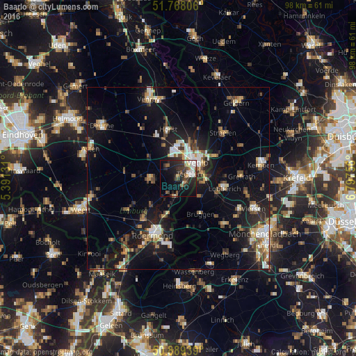
Analysis of Baarlo night lights 2016
Square area 10x10 km:
100  5.32%
5.32%
90-99 4.62%
80-89 2.1%
70-79 0.98%
60-69 2.8%
50-59 4.76%
40-49 4.48%
30-39 7.98%
20-29 13.59%
10-19 22.13%
0-9 31.23%
5.32%90-99
4.62%80-89
2.1%70-79
0.98%60-69
2.8%50-59
4.76%40-49
4.48%30-39
7.98%20-29
13.59%10-19
22.13%0-9
31.23%Square area 50x50 km:
100 1.71%
90-99 2.39%
80-89 1.37%
70-79 1.52%
60-69 1.52%
50-59 2.32%
40-49 2.72%
30-39 1.95%
20-29 4.02%
10-19 13.51%
0-9 66.98%
1.71%90-99
2.39%80-89
1.37%70-79
1.52%60-69
1.52%50-59
2.32%40-49
2.72%30-39
1.95%20-29
4.02%10-19
13.51%0-9
66.98%Clear (daylight) street map image can be seen on geolist.org.
Map coordinates:
51° 46' 5" North, 5° 23' 28.7" East
51° 19' 51" North, 6° 5' 40" East
50° 53' 21.8" North, 6° 47' 51.2" East
Some cities around Baarlo sort by population:
• Venlo
6.7 km =4.2 mi,  49°
49°
• Tegelen
3.3 km =2.1 mi,  62°
62°
• Brüggen, DE
11.8 km =7.3 mi,  148°
148°
• Panningen
8 km =5 mi,  266°
266°
• Reuver
5.3 km =3.3 mi,  192°
192°
• Helden
6.7 km =4.2 mi,  258°
258°
• Maasbree
4.4 km =2.7 mi,  312°
312°
• Sevenum
9.9 km =6.2 mi,  336°
336°
2759549 (p: 5,215)
Sources (retrieved 2019-11-25):
» Earth at Night: Flat Maps 2012, 2016