Kerkdriel night lights from space
Night Light of Kerkdriel (Gelderland) from space (Netherlands) Src. Average luminocity for 10x10km area is 26.5518% and for 50x50km: 23.6621%.
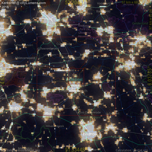
Analysis of Kerkdriel night lights 2016
Square area 10x10 km:
 2.24%
2.24%90-99
2.38%80-89
2.38%70-79
4.34%60-69
3.92%50-59
2.52%40-49
2.8%30-39
6.72%20-29
19.61%10-19
23.39%0-9
29.69%Square area 50x50 km:
3.29%90-99
4.15%80-89
1.82%70-79
2.32%60-69
2.74%50-59
2.78%40-49
2.5%30-39
3.2%20-29
6.79%10-19
29.14%0-9
41.27%Clear (daylight) street map image can be seen on geolist.org.
Map coordinates:
52° 12' 16.8" North, 4° 37' 53.8" East
51° 46' 18" North, 5° 20' 5" East
51° 20' 4.1" North, 6° 2' 16.3" East
Some cities around Kerkdriel sort by population:
• 's-Hertogenbosch
8.3 km =5.2 mi,  194°
194°
• Oss
12.6 km =7.8 mi,  93°
93°
• Zaltbommel
7.5 km =4.7 mi,  304°
304°
• Geldermalsen
12.5 km =7.8 mi,  345°
345°
• Vught
13.6 km =8.5 mi, 193°
• Heesch
13.9 km =8.6 mi,  107°
107°
• De Kruiskamp
9.5 km =5.9 mi,  212°
212°
• Aalburg
14.1 km =8.8 mi,  262°
262°
2752947 (p: 6,580)
Sources (retrieved 2019-11-25):
» Earth at Night: Flat Maps 2012, 2016