Hasselt night lights from space
Night Light of Hasselt (Overijssel) from space (Netherlands) Src. Average luminocity for 10x10km area is 10.4709% and for 50x50km: 8.3817%.
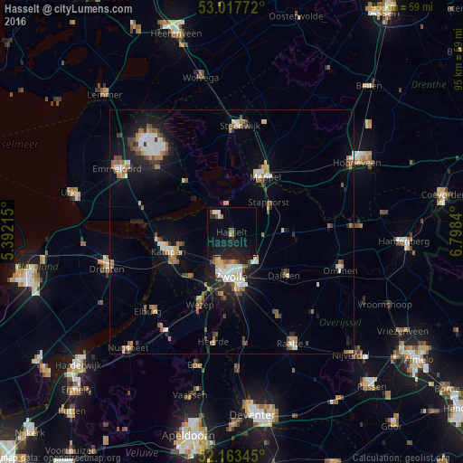
Analysis of Hasselt night lights 2016
Square area 10x10 km:
 0.93%
0.93%90-99
1.19%80-89
0.13%70-79
0.4%60-69
0.79%50-59
1.46%40-49
0.66%30-39
0.53%20-29
3.44%10-19
20.77%0-9
69.71%Square area 50x50 km:
1.13%90-99
1.42%80-89
0.63%70-79
0.88%60-69
1.14%50-59
1.32%40-49
0.99%30-39
0.78%20-29
1.6%10-19
6.32%0-9
83.8%Clear (daylight) street map image can be seen on geolist.org.
Map coordinates:
53° 1' 3.8" North, 5° 23' 31.7" East
52° 35' 33.6" North, 6° 5' 43" East
52° 9' 48.4" North, 6° 47' 54.2" East
Some cities around Hasselt sort by population:
• Zwolle
8.9 km =5.5 mi,  180°
180°
• Kampen
13.1 km =8.1 mi,  251°
251°
• Meppel
13.3 km =8.3 mi,  30°
30°
• Dalfsen
14.2 km =8.8 mi,  129°
129°
• Staphorst
9.7 km =6 mi,  53°
53°
• Hattem
13.3 km =8.3 mi,  189°
189°
• Heino
19.7 km =12.2 mi,  151°
151°
• Frankhuis
7.7 km =4.8 mi, 193°
2754779 (p: 6,959)
Sources (retrieved 2019-11-25):
» Earth at Night: Flat Maps 2012, 2016