Heino night lights from space
Night Light of Heino (Overijssel) from space (Netherlands) Src. Average luminocity for 10x10km area is 3.6768% and for 50x50km: 8.8082%.
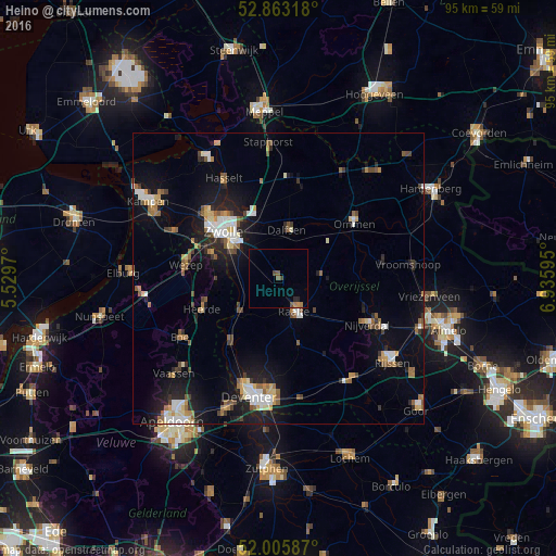
Analysis of Heino night lights 2016
Square area 10x10 km:
100  0%
0%
90-99 0%
80-89 0%
70-79 0.51%
60-69 1.01%
50-59 1.01%
40-49 1.52%
30-39 0%
20-29 1.01%
10-19 0%
0-9 94.95%
0%90-99
0%80-89
0%70-79
0.51%60-69
1.01%50-59
1.01%40-49
1.52%30-39
0%20-29
1.01%10-19
0%0-9
94.95%Square area 50x50 km:
100 1.19%
90-99 1.31%
80-89 0.77%
70-79 0.9%
60-69 1.04%
50-59 1.58%
40-49 0.96%
30-39 0.89%
20-29 1.89%
10-19 6.8%
0-9 82.67%
1.19%90-99
1.31%80-89
0.77%70-79
0.9%60-69
1.04%50-59
1.58%40-49
0.96%30-39
0.89%20-29
1.89%10-19
6.8%0-9
82.67%Clear (daylight) street map image can be seen on geolist.org.
Map coordinates:
52° 51' 47.4" North, 5° 31' 46.9" East
52° 26' 11.8" North, 6° 13' 58.2" East
52° 0' 21.1" North, 6° 56' 9.4" East
Some cities around Heino sort by population:
• Zwolle
12.6 km =7.8 mi,  311°
311°
• Dalfsen
8.5 km =5.3 mi,  11°
11°
• Raalte
6.3 km =3.9 mi,  153°
153°
• Hattem
12.2 km =7.6 mi,  290°
290°
• Ommen
15.8 km =9.8 mi,  53°
53°
• Heerde
14.2 km =8.8 mi,  247°
247°
• Frankhuis
14.9 km =9.3 mi, 311°
• Wijhe
8.7 km =5.4 mi,  230°
230°
2754502 (p: 6,459)
Sources (retrieved 2019-11-25):
» Earth at Night: Flat Maps 2012, 2016