Staphorst night lights from space
Night Light of Staphorst (Overijssel) from space (Netherlands) Src. Average luminocity for 10x10km area is 4.963% and for 50x50km: 6.8824%.
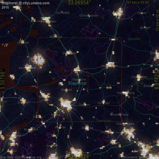
Analysis of Staphorst night lights 2016
Square area 10x10 km:
 0%
0%90-99
0%80-89
0.13%70-79
0.4%60-69
0.66%50-59
1.72%40-49
1.32%30-39
0.53%20-29
0.53%10-19
2.65%0-9
92.06%Square area 50x50 km:
0.96%90-99
1.16%80-89
0.56%70-79
0.79%60-69
0.78%50-59
1.09%40-49
0.73%30-39
0.58%20-29
1.13%10-19
5.05%0-9
87.16%Clear (daylight) street map image can be seen on geolist.org.
Map coordinates:
53° 4' 10.3" North, 5° 30' 28.7" East
52° 38' 42" North, 6° 12' 40" East
52° 12' 58.6" North, 6° 54' 51.2" East
Some cities around Staphorst sort by population:
• Zwolle
16.7 km =10.4 mi,  208°
208°
• Hoogeveen
19.8 km =12.3 mi,  64°
64°
• Meppel
5.8 km =3.6 mi,  348°
348°
• Dalfsen
15.1 km =9.4 mi,  168°
168°
• Steenwijk
17 km =10.6 mi,  339°
339°
• Ommen
19.8 km =12.3 mi,  134°
134°
• Hasselt
9.7 km =6 mi,  233°
233°
• Frankhuis
16.5 km =10.3 mi,  215°
215°
2746839 (p: 15,765)
Sources (retrieved 2019-11-25):
» Earth at Night: Flat Maps 2012, 2016