Duiven night lights from space
Night Light of Duiven (Gelderland) from space (Netherlands) Src. Average luminocity for 10x10km area is 37.6301% and for 50x50km: 17.5391%.

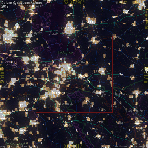
Analysis of Duiven night lights 2016
Square area 10x10 km:
100  5.43%
5.43%
90-99 6.94%
80-89 5.68%
70-79 4.92%
60-69 3.03%
50-59 6.19%
40-49 3.16%
30-39 4.42%
20-29 11.99%
10-19 40.53%
0-9 7.7%
5.43%90-99
6.94%80-89
5.68%70-79
4.92%60-69
3.03%50-59
6.19%40-49
3.16%30-39
4.42%20-29
11.99%10-19
40.53%0-9
7.7%Square area 50x50 km:
100 2.14%
90-99 2.66%
80-89 1.96%
70-79 1.68%
60-69 2.56%
50-59 2.46%
40-49 2.37%
30-39 2.56%
20-29 5.39%
10-19 15.44%
0-9 60.78%
2.14%90-99
2.66%80-89
1.96%70-79
1.68%60-69
2.56%50-59
2.46%40-49
2.37%30-39
2.56%20-29
5.39%10-19
15.44%0-9
60.78%Clear (daylight) street map image can be seen on geolist.org.
Map coordinates:
52° 22' 40.7" North, 5° 18' 38.8" East
51° 56' 48" North, 6° 0' 50" East
51° 30' 40.2" North, 6° 43' 1.3" East
Some cities around Duiven sort by population:
• Arnhem
8 km =5 mi,  297°
297°
• Zevenaar
4.3 km =2.7 mi,  115°
115°
• Velp
6 km =3.7 mi,  332°
332°
• Bemmel
10 km =6.2 mi,  232°
232°
• Doesburg
11.3 km =7 mi,  49°
49°
• Rheden
6.6 km =4.1 mi,  9°
9°
• Westervoort
3 km =1.9 mi,  289°
289°
• Gendt
8.2 km =5.1 mi,  201°
201°
2756507 (p: 25,469)
Sources (retrieved 2019-11-25):
» Earth at Night: Flat Maps 2012, 2016