Brüggen night lights from space
Night Light of Brüggen (North Rhine-Westphalia) from space (Germany) Src. Average luminocity for 10x10km area is 4.8081% and for 50x50km: 17.6404%.
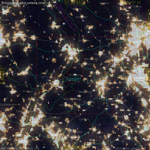
Analysis of Brüggen night lights 2016
Square area 10x10 km:
 0%
0%90-99
0.56%80-89
0%70-79
0%60-69
0.28%50-59
1.96%40-49
1.68%30-39
0%20-29
0.56%10-19
1.96%0-9
93%Square area 50x50 km:
1.93%90-99
2.7%80-89
1.46%70-79
1.67%60-69
2.04%50-59
2.7%40-49
3.44%30-39
2.5%20-29
5.96%10-19
15.47%0-9
60.12%Clear (daylight) street map image can be seen on geolist.org.
Map coordinates:
51° 40' 43" North, 5° 28' 50.3" East
51° 14' 25.9" North, 6° 11' 1.5" East
50° 47' 53.6" North, 6° 53' 12.8" East
Some cities around Brüggen sort by population:
• Venlo, NL
14.4 km =8.9 mi,  355°
355°
• Nettetal
10.9 km =6.8 mi,  39°
39°
• Wegberg
13 km =8.1 mi,  147°
147°
• Tegelen, NL
12 km =7.5 mi,  343°
343°
• Schwalmtal
6.4 km =4 mi,  114°
114°
• Niederkrüchten
5.1 km =3.2 mi, 153°
• Reuver, NL
8.8 km =5.5 mi,  303°
303°
• Baarlo, NL
11.8 km =7.3 mi,  328°
328°
2943336 (p: 16,105)
Sources (retrieved 2019-11-25):
» Earth at Night: Flat Maps 2012, 2016