Axel night lights from space
Night Light of Axel (Zeeland) from space (Netherlands) Src. Average luminocity for 10x10km area is 14.1162% and for 50x50km: 28.3053%.
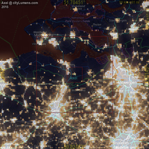
Analysis of Axel night lights 2016
Square area 10x10 km:
 2.52%
2.52%90-99
1.68%80-89
1.96%70-79
1.68%60-69
0.56%50-59
1.96%40-49
0.28%30-39
1.96%20-29
1.82%10-19
20.31%0-9
65.27%Square area 50x50 km:
4.24%90-99
4.55%80-89
2.88%70-79
2.99%60-69
4%50-59
4.15%40-49
5.63%30-39
6.07%20-29
9.86%10-19
15.36%0-9
40.27%Clear (daylight) street map image can be seen on geolist.org.
Map coordinates:
51° 42' 16.2" North, 3° 12' 18.7" East
51° 16' 0" North, 3° 54' 30" East
50° 49' 28.6" North, 4° 36' 41.2" East
Some cities around Axel sort by population:
• Lokeren, BE
19.1 km =11.9 mi,  161°
161°
• Terneuzen
9.5 km =5.9 mi,  323°
323°
• Sint-Gillis-Waas, BE
15.9 km =9.9 mi,  109°
109°
• Stekene, BE
10.9 km =6.8 mi,  125°
125°
• Assenede, BE
11.9 km =7.4 mi,  247°
247°
• Zelzate, BE
11.1 km =6.9 mi,  219°
219°
• Wachtebeke, BE
11.2 km =7 mi,  193°
193°
• Moerbeke, BE
10.4 km =6.5 mi,  171°
171°
2759594 (p: 8,149)
Sources (retrieved 2019-11-25):
» Earth at Night: Flat Maps 2012, 2016