Sint-Gillis-Waas night lights from space
Night Light of Sint-Gillis-Waas (Flanders) from space (Belgium) Src. Average luminocity for 10x10km area is 37.5336% and for 50x50km: 43.6827%.
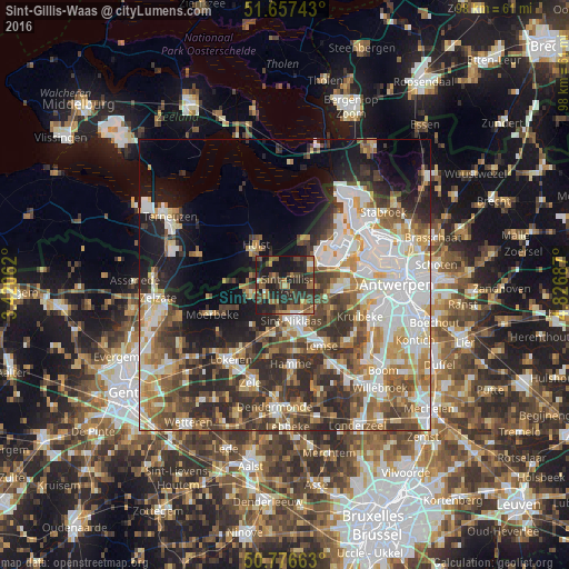
Analysis of Sint-Gillis-Waas night lights 2016
Square area 10x10 km:
 0.7%
0.7%90-99
2.38%80-89
1.82%70-79
3.22%60-69
11.62%50-59
6.58%40-49
11.9%30-39
13.03%20-29
26.89%10-19
21.71%0-9
0.14%Square area 50x50 km:
9.61%90-99
9.51%80-89
4.53%70-79
5.07%60-69
6.24%50-59
5.77%40-49
7%30-39
7.05%20-29
10.12%10-19
10.3%0-9
24.79%Clear (daylight) street map image can be seen on geolist.org.
Map coordinates:
51° 39' 26.7" North, 3° 25' 14.2" East
51° 13' 8.9" North, 4° 7' 25.5" East
50° 46' 35.9" North, 4° 49' 36.7" East
Some cities around Sint-Gillis-Waas sort by population:
• Beveren
9.3 km =5.8 mi,  95°
95°
• Temse
11.9 km =7.4 mi,  148°
148°
• Hamme
13.5 km =8.4 mi,  176°
176°
• Zwijndrecht
14.1 km =8.8 mi,  89°
89°
• Stekene
6.2 km =3.9 mi,  260°
260°
• Kruibeke
14.3 km =8.9 mi,  112°
112°
• Waasmunster
12.9 km =8 mi,  191°
191°
• Moerbeke
14.4 km =8.9 mi,  249°
249°
2786694 (p: 17,658)
Sources (retrieved 2019-11-25):
» Earth at Night: Flat Maps 2012, 2016