Moerbeke night lights from space
Night Light of Moerbeke (Flanders) from space (Belgium) Src. Average luminocity for 10x10km area is 17.9104% and for 50x50km: 37.402%.
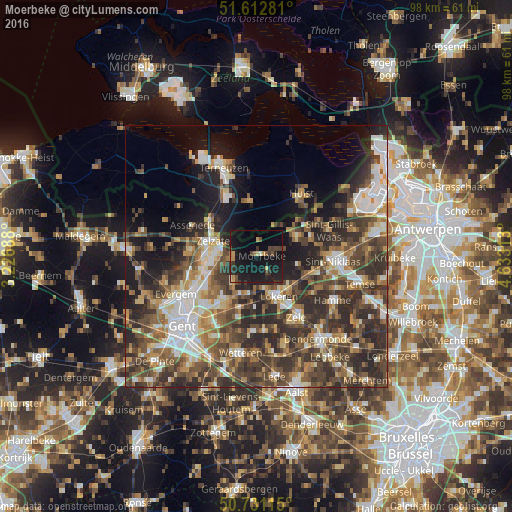
Analysis of Moerbeke night lights 2016
Square area 10x10 km:
 0%
0%90-99
0.94%80-89
1.07%70-79
2.94%60-69
1.07%50-59
1.34%40-49
3.88%30-39
4.01%20-29
7.49%10-19
40.11%0-9
37.17%Square area 50x50 km:
5.4%90-99
6.17%80-89
3.63%70-79
4.13%60-69
5.99%50-59
6.31%40-49
9.6%30-39
9.25%20-29
12.16%10-19
11.04%0-9
26.31%Clear (daylight) street map image can be seen on geolist.org.
Map coordinates:
51° 36' 46.1" North, 3° 13' 36.8" East
51° 10' 26.7" North, 3° 55' 48" East
50° 43' 52.1" North, 4° 37' 59.3" East
Some cities around Moerbeke sort by population:
• Lokeren
9 km =5.6 mi,  150°
150°
• Lochristi
11 km =6.8 mi,  218°
218°
• Stekene
8.4 km =5.2 mi,  61°
61°
• Assenede
13.8 km =8.6 mi,  294°
294°
• Zelzate
8.7 km =5.4 mi,  281°
281°
• Waasmunster
13.3 km =8.3 mi,  124°
124°
• Axel, NL
10.4 km =6.5 mi,  351°
351°
• Wachtebeke
4.1 km =2.5 mi,  261°
261°
2791120 (p: 5,855)
Sources (retrieved 2019-11-25):
» Earth at Night: Flat Maps 2012, 2016