San Jorge night lights from space
Night Light of San Jorge (Rivas) from space (Nicaragua) Src. Average luminocity for 10x10km area is 10.0996% and for 50x50km: 0.9796%.
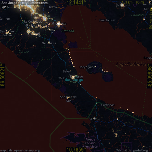
Analysis of San Jorge night lights 2016
Square area 10x10 km:
 0.65%
0.65%90-99
1.08%80-89
0.43%70-79
1.52%60-69
1.73%50-59
2.81%40-49
1.73%30-39
2.6%20-29
4.33%10-19
1.3%0-9
81.82%Square area 50x50 km:
0.03%90-99
0.11%80-89
0.34%70-79
0.15%60-69
0.08%50-59
0.11%40-49
0.1%30-39
0.17%20-29
0.25%10-19
0.07%0-9
98.6%Clear (daylight) street map image can be seen on geolist.org.
Map coordinates:
12° 8' 38.8" North, 86° 30' 22.4" West
11° 27' 21" North, 85° 48' 11.1" West
10° 45' 57.2" North, 85° 5' 59.9" West
Some cities around San Jorge sort by population:
• Granada
55.3 km =34.4 mi,  342°
342°
• Rivas
3.3 km =2.1 mi,  230°
230°
• Nandaime
43.1 km =26.8 mi,  320°
320°
• Diriomo
54 km =33.6 mi,  329°
329°
• Niquinohomo
59.2 km =36.8 mi, 327°
• Santa Teresa
55 km =34.2 mi,  305°
305°
• Belén
10.8 km =6.7 mi,  299°
299°
• Potosí
7.2 km =4.5 mi, 306°
3616794 (p: 7,158)
Sources (retrieved 2019-11-25):
» Earth at Night: Flat Maps 2012, 2016