Potosí night lights from space
Night Light of Potosí (Rivas) from space (Nicaragua) Src. Average luminocity for 10x10km area is 3.3745% and for 50x50km: 0.8822%.
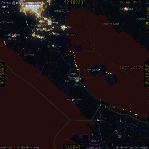
Analysis of Potosí night lights 2016
Square area 10x10 km:
 0%
0%90-99
0%80-89
0%70-79
0.43%60-69
0.43%50-59
0.65%40-49
0.43%30-39
1.3%20-29
2.81%10-19
0.65%0-9
93.29%Square area 50x50 km:
0.03%90-99
0.11%80-89
0.3%70-79
0.11%60-69
0.07%50-59
0.11%40-49
0.07%30-39
0.15%20-29
0.25%10-19
0.07%0-9
98.75%Clear (daylight) street map image can be seen on geolist.org.
Map coordinates:
12° 10' 56.4" North, 86° 33' 35.7" West
11° 29' 39" North, 85° 51' 24.5" West
10° 48' 15.5" North, 85° 9' 13.2" West
Some cities around Potosí sort by population:
• Granada
49.6 km =30.8 mi,  347°
347°
• Rivas
7.2 km =4.5 mi,  152°
152°
• Nandaime
36.2 km =22.5 mi,  323°
323°
• Diriomo
47.5 km =29.5 mi,  333°
333°
• San Juan del Sur
26.9 km =16.7 mi,  183°
183°
• San Jorge
7.2 km =4.5 mi,  126°
126°
• Santa Teresa
47.8 km =29.7 mi,  305°
305°
• Belén
3.7 km =2.3 mi,  285°
285°
3617187 (p: 5,222)
Sources (retrieved 2019-11-25):
» Earth at Night: Flat Maps 2012, 2016