Uruobo-Okija night lights from space
Night Light of Uruobo-Okija (Anambra) from space (Nigeria) Src. Average luminocity for 10x10km area is 3.1694% and for 50x50km: 3.3224%.
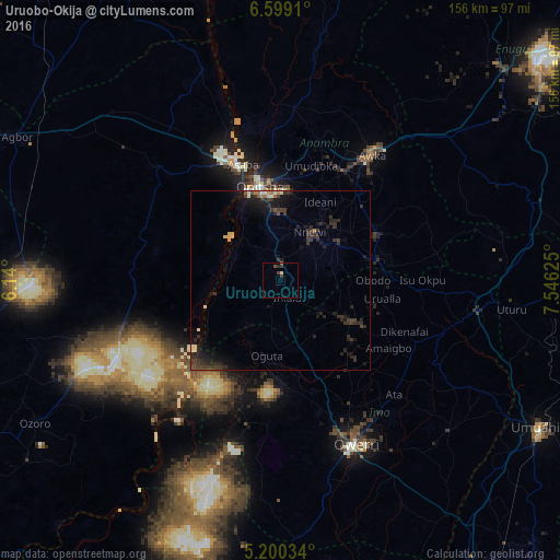
Analysis of Uruobo-Okija night lights 2016
Square area 10x10 km:
100  0%
0%
90-99 0.83%
80-89 0%
70-79 0%
60-69 0.21%
50-59 0.62%
40-49 1.65%
30-39 1.65%
20-29 0.83%
10-19 0.83%
0-9 93.39%
0%90-99
0.83%80-89
0%70-79
0%60-69
0.21%50-59
0.62%40-49
1.65%30-39
1.65%20-29
0.83%10-19
0.83%0-9
93.39%Square area 50x50 km:
100 0.05%
90-99 0.39%
80-89 0.33%
70-79 0.18%
60-69 0.31%
50-59 0.2%
40-49 0.51%
30-39 1.81%
20-29 1.88%
10-19 3.06%
0-9 91.29%
0.05%90-99
0.39%80-89
0.33%70-79
0.18%60-69
0.31%50-59
0.2%40-49
0.51%30-39
1.81%20-29
1.88%10-19
3.06%0-9
91.29%Clear (daylight) street map image can be seen on geolist.org.
Map coordinates:
6° 35' 56.8" North, 6° 8' 24" East
5° 54' 0.6" North, 6° 50' 35.2" East
5° 12' 1.2" North, 7° 32' 46.5" East
Some cities around Uruobo-Okija sort by population:
• Atani
16.4 km =10.2 mi,  319°
319°
• Nnewi
15.6 km =9.7 mi,  31°
31°
• Ihiala
5.4 km =3.4 mi,  160°
160°
• Igbo-Ukwu
23.6 km =14.7 mi,  56°
56°
• Ozubulu
6.5 km =4 mi,  9°
9°
• Uga
26.4 km =16.4 mi,  81°
81°
• Oguta
21.4 km =13.3 mi,  190°
190°
• Orlu
24.2 km =15 mi,  118°
118°
2319642 (p: 13,898)
Sources (retrieved 2019-11-25):
» Earth at Night: Flat Maps 2012, 2016