Obiaruku night lights from space
Night Light of Obiaruku (Delta) from space (Nigeria) Src. Average luminocity for 10x10km area is 22.9463% and for 50x50km: 8.0831%.
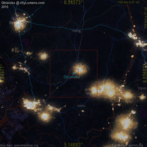
Analysis of Obiaruku night lights 2016
Square area 10x10 km:
 0.41%
0.41%90-99
4.13%80-89
3.31%70-79
2.48%60-69
3.1%50-59
3.31%40-49
6.82%30-39
5.58%20-29
4.55%10-19
16.94%0-9
49.38%Square area 50x50 km:
0.38%90-99
1.41%80-89
1.1%70-79
0.96%60-69
1.26%50-59
1.4%40-49
1.92%30-39
2.34%20-29
1.86%10-19
4.19%0-9
83.19%Clear (daylight) street map image can be seen on geolist.org.
Map coordinates:
6° 32' 44.6" North, 5° 26' 59.2" East
5° 50' 48.2" North, 6° 9' 10.4" East
5° 8' 48.6" North, 6° 51' 21.7" East
Some cities around Obiaruku sort by population:
• Sapele
52.9 km =32.9 mi,  275°
275°
• Ughelli
43 km =26.7 mi,  202°
202°
• Agbor
45.5 km =28.3 mi,  5°
5°
• Ogwashi-Uku
55.2 km =34.3 mi,  48°
48°
• Kwale
34.7 km =21.6 mi,  116°
116°
• Umunede
49.7 km =30.9 mi,  20°
20°
• Abraka
8.2 km =5.1 mi,  220°
220°
• Orerokpe
37.2 km =23.1 mi,  231°
231°
2328276 (p: 11,936)
Sources (retrieved 2019-11-25):
» Earth at Night: Flat Maps 2012, 2016