Pantai Remis night lights from space
Night Light of Pantai Remis (Perak) from space (Malaysia) Src. Average luminocity for 10x10km area is 12.876% and for 50x50km: 4.9927%.
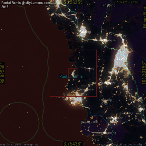
Analysis of Pantai Remis night lights 2016
Square area 10x10 km:
 1.03%
1.03%90-99
1.45%80-89
1.03%70-79
2.48%60-69
2.27%50-59
2.07%40-49
2.69%30-39
1.03%20-29
1.45%10-19
1.86%0-9
82.64%Square area 50x50 km:
0.34%90-99
0.5%80-89
0.15%70-79
0.52%60-69
0.96%50-59
1.29%40-49
1.36%30-39
0.98%20-29
1.24%10-19
2.97%0-9
89.69%Clear (daylight) street map image can be seen on geolist.org.
Map coordinates:
5° 9' 22.9" North, 99° 55' 32.4" East
4° 27' 20.5" North, 100° 37' 43.7" East
3° 45' 15.8" North, 101° 19' 54.9" East
Some cities around Pantai Remis sort by population:
• Ipoh
52.3 km =32.5 mi,  74°
74°
• Taiping
45.3 km =28.1 mi,  14°
14°
• Simpang Empat
55 km =34.2 mi,  0°
0°
• Batu Gajah
45.7 km =28.4 mi,  88°
88°
• Lumut
24.8 km =15.4 mi,  179°
179°
• Kuala Kangsar
48.3 km =30 mi,  44°
44°
• Bagan Serai
62.5 km =38.8 mi,  351°
351°
• Kampar
60.3 km =37.5 mi,  106°
106°
1752256 (p: 16,317)
Sources (retrieved 2019-11-25):
» Earth at Night: Flat Maps 2012, 2016