Zinapécuaro night lights from space
Night Light of Zinapécuaro (Michoacán) from space (Mexico) Src. Average luminocity for 10x10km area is 19.8182% and for 50x50km: 6.7276%.
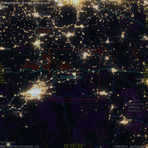
Analysis of Zinapécuaro night lights 2016
Square area 10x10 km:
 0.43%
0.43%90-99
1.3%80-89
6.06%70-79
3.03%60-69
3.46%50-59
2.38%40-49
2.81%30-39
0.43%20-29
1.73%10-19
7.58%0-9
70.78%Square area 50x50 km:
0.08%90-99
0.34%80-89
1.21%70-79
1%60-69
0.97%50-59
0.72%40-49
1.81%30-39
1.31%20-29
1.5%10-19
4.04%0-9
87.02%Clear (daylight) street map image can be seen on geolist.org.
Map coordinates:
20° 31' 11.9" North, 101° 31' 54.1" West
19° 51' 36.2" North, 100° 49' 42.9" West
19° 11' 50.6" North, 100° 7' 31.6" West
Some cities around Zinapécuaro sort by population:
• Acámbaro
22 km =13.7 mi,  30°
30°
• Queréndaro
8.6 km =5.3 mi,  229°
229°
• Álvaro Obregón
22.5 km =14 mi,  258°
258°
• Estación Queréndaro
12.8 km =8 mi,  281°
281°
• Santa Ana Maya
26 km =16.2 mi,  308°
308°
• Indaparapeo
16.8 km =10.4 mi,  241°
241°
• Irámuco
14.9 km =9.3 mi,  319°
319°
• Charo
25.8 km =16 mi, 241°
3979665 (p: 15,875)
Sources (retrieved 2019-11-25):
» Earth at Night: Flat Maps 2012, 2016