Queréndaro night lights from space
Night Light of Queréndaro (Michoacán) from space (Mexico) Src. Average luminocity for 10x10km area is 6.1963% and for 50x50km: 7.1013%.
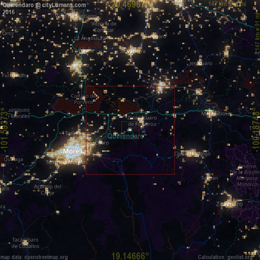
Analysis of Queréndaro night lights 2016
Square area 10x10 km:
 0%
0%90-99
0%80-89
1.65%70-79
0%60-69
0%50-59
0.41%40-49
2.48%30-39
1.65%20-29
0.83%10-19
0.83%0-9
92.15%Square area 50x50 km:
0.09%90-99
0.38%80-89
1.36%70-79
1.03%60-69
1.44%50-59
0.68%40-49
1.43%30-39
1.38%20-29
2.13%10-19
4.17%0-9
85.91%Clear (daylight) street map image can be seen on geolist.org.
Map coordinates:
20° 28' 10.8" North, 101° 35' 37.4" West
19° 48' 34.3" North, 100° 53' 26.2" West
19° 8' 48" North, 100° 11' 14.9" West
Some cities around Queréndaro sort by population:
• Zinapécuaro
8.6 km =5.3 mi,  49°
49°
• Álvaro Obregón
15.7 km =9.8 mi,  274°
274°
• Estación Queréndaro
10.2 km =6.3 mi,  323°
323°
• Fraccionamiento Misión del Valle
24.7 km =15.3 mi,  258°
258°
• Santa Ana Maya
25.9 km =16.1 mi,  327°
327°
• Indaparapeo
8.6 km =5.3 mi,  253°
253°
• Irámuco
17.2 km =10.7 mi,  349°
349°
• Charo
17.5 km =10.9 mi, 247°
3991170 (p: 9,105)
Sources (retrieved 2019-11-25):
» Earth at Night: Flat Maps 2012, 2016