Charo night lights from space
Night Light of Charo (Michoacán) from space (Mexico) Src. Average luminocity for 10x10km area is 19.4339% and for 50x50km: 14.991%.
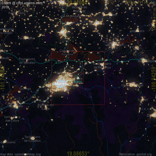
Analysis of Charo night lights 2016
Square area 10x10 km:
 0%
0%90-99
1.03%80-89
4.34%70-79
0.62%60-69
1.65%50-59
1.03%40-49
4.13%30-39
4.34%20-29
14.05%10-19
28.51%0-9
40.29%Square area 50x50 km:
1.9%90-99
2.42%80-89
2.92%70-79
2.23%60-69
2.3%50-59
1.31%40-49
2.16%30-39
1.9%20-29
3.62%10-19
5.84%0-9
73.4%Clear (daylight) street map image can be seen on geolist.org.
Map coordinates:
20° 24' 36.1" North, 101° 44' 55.8" West
19° 44' 58.8" North, 101° 2' 44.6" West
19° 5' 11.5" North, 100° 20' 33.3" West
Some cities around Charo sort by population:
• Morelia
15.5 km =9.6 mi,  249°
249°
• Álvaro Obregón
7.9 km =4.9 mi,  4°
4°
• Fraccionamiento Misión del Valle
8.1 km =5 mi,  282°
282°
• Indaparapeo
9.1 km =5.7 mi,  62°
62°
• La Aldea
9.4 km =5.8 mi,  265°
265°
• Tarímbaro
14.7 km =9.1 mi,  290°
290°
• Fraccionamiento Galaxia Tarímbaro
15.6 km =9.7 mi, 274°
• Fraccionamiento Metrópolis II
16.6 km =10.3 mi, 272°
4014450 (p: 5,207)
Sources (retrieved 2019-11-25):
» Earth at Night: Flat Maps 2012, 2016