Zacatlán night lights from space
Night Light of Zacatlán (Puebla) from space (Mexico) Src. Average luminocity for 10x10km area is 31.0216% and for 50x50km: 7.2623%.

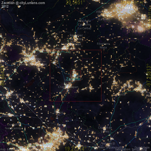
Analysis of Zacatlán night lights 2016
Square area 10x10 km:
 0.87%
0.87%90-99
1.3%80-89
6.93%70-79
6.71%60-69
5.19%50-59
3.68%40-49
9.09%30-39
3.9%20-29
4.98%10-19
37.01%0-9
20.35%Square area 50x50 km:
0.05%90-99
0.16%80-89
0.92%70-79
0.84%60-69
0.97%50-59
0.96%40-49
2.39%30-39
2.18%20-29
2.14%10-19
6.19%0-9
83.2%Clear (daylight) street map image can be seen on geolist.org.
Map coordinates:
20° 35' 42.4" North, 98° 39' 51.8" West
19° 56' 7.8" North, 97° 57' 40.5" West
19° 16' 23.3" North, 97° 15' 29.3" West
Some cities around Zacatlán sort by population:
• Huauchinango
28.2 km =17.5 mi,  339°
339°
• Xicotepec de Juárez
37.9 km =23.5 mi,  0°
0°
• Chignahuapan
13 km =8.1 mi,  214°
214°
• Cuautepec de Hinojosa
38.1 km =23.7 mi,  286°
286°
• Tlaxco
39.4 km =24.5 mi,  204°
204°
• Necaxa
31.3 km =19.4 mi,  350°
350°
• Nuevo Necaxa
30.9 km =19.2 mi, 351°
• Tenango de las Flores
30.2 km =18.8 mi, 354°
3514148 (p: 33,736)
Sources (retrieved 2019-11-25):
» Earth at Night: Flat Maps 2012, 2016