Chignahuapan night lights from space
Night Light of Chignahuapan (Puebla) from space (Mexico) Src. Average luminocity for 10x10km area is 25.0996% and for 50x50km: 6.3164%.
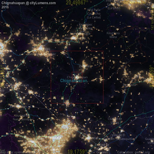
Analysis of Chignahuapan night lights 2016
Square area 10x10 km:
 0.43%
0.43%90-99
1.95%80-89
3.03%70-79
3.25%60-69
6.49%50-59
4.33%40-49
6.06%30-39
4.11%20-29
6.93%10-19
22.73%0-9
40.69%Square area 50x50 km:
0.07%90-99
0.15%80-89
1.06%70-79
0.71%60-69
0.85%50-59
0.8%40-49
1.86%30-39
1.88%20-29
1.67%10-19
3.97%0-9
86.98%Clear (daylight) street map image can be seen on geolist.org.
Map coordinates:
20° 29' 55.2" North, 98° 44' 5.4" West
19° 50' 19.2" North, 98° 1' 54.2" West
19° 10' 33.2" North, 97° 19' 42.9" West
Some cities around Chignahuapan sort by population:
• Huauchinango
37.3 km =23.2 mi,  356°
356°
• Zacatlán
13 km =8.1 mi,  34°
34°
• Cuautepec de Hinojosa
36.4 km =22.6 mi,  306°
306°
• Santiago Tulantepec
40.4 km =25.1 mi,  302°
302°
• Tlaxco
26.6 km =16.5 mi,  200°
200°
• Necaxa
41.6 km =25.8 mi,  2°
2°
• Nuevo Necaxa
41.4 km =25.7 mi, 3°
• Tenango de las Flores
41.1 km =25.5 mi,  6°
6°
3530908 (p: 19,608)
Sources (retrieved 2019-11-25):
» Earth at Night: Flat Maps 2012, 2016