Necaxa night lights from space
Night Light of Necaxa (Puebla) from space (Mexico) Src. Average luminocity for 10x10km area is 36.0417% and for 50x50km: 8.0405%.
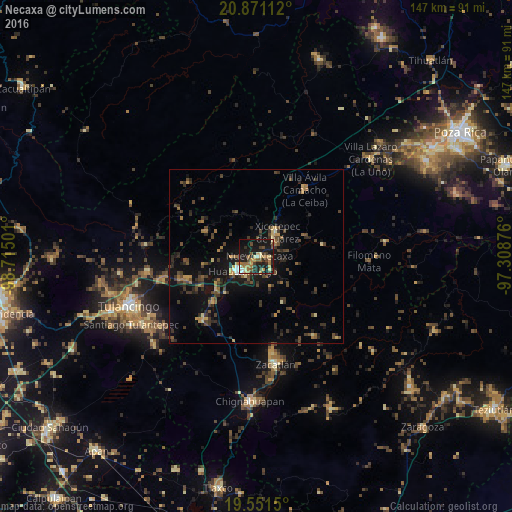
Analysis of Necaxa night lights 2016
Square area 10x10 km:
 2.38%
2.38%90-99
2.58%80-89
5.56%70-79
5.56%60-69
9.52%50-59
4.76%40-49
5.95%30-39
5.95%20-29
9.92%10-19
40.08%0-9
7.74%Square area 50x50 km:
0.17%90-99
0.23%80-89
0.81%70-79
0.95%60-69
1.34%50-59
0.96%40-49
2.48%30-39
2.55%20-29
2.41%10-19
7.47%0-9
80.62%Clear (daylight) street map image can be seen on geolist.org.
Map coordinates:
20° 52' 16" North, 98° 42' 54" West
20° 12' 45.8" North, 98° 0' 42.8" West
19° 33' 5.4" North, 97° 18' 31.5" West
Some cities around Necaxa sort by population:
• Huauchinango
6.2 km =3.9 mi,  226°
226°
• Xicotepec de Juárez
8.8 km =5.5 mi,  36°
36°
• Zacatlán
31.3 km =19.4 mi,  170°
170°
• Filomeno Mata
32.2 km =20 mi,  92°
92°
• Villa Avila Camacho
23.7 km =14.7 mi, 35°
• Nuevo Necaxa
0.6 km =0.4 mi,  114°
114°
• Tenango de las Flores
2.6 km =1.6 mi, 107°
• Santa Ana Hueytlalpan
31.6 km =19.6 mi,  262°
262°
3522777 (p: 8,375)
Sources (retrieved 2019-11-25):
» Earth at Night: Flat Maps 2012, 2016