Yerbabuena night lights from space
Night Light of Yerbabuena (Guanajuato) from space (Mexico) Src. Average luminocity for 10x10km area is 53.3571% and for 50x50km: 18.3331%.
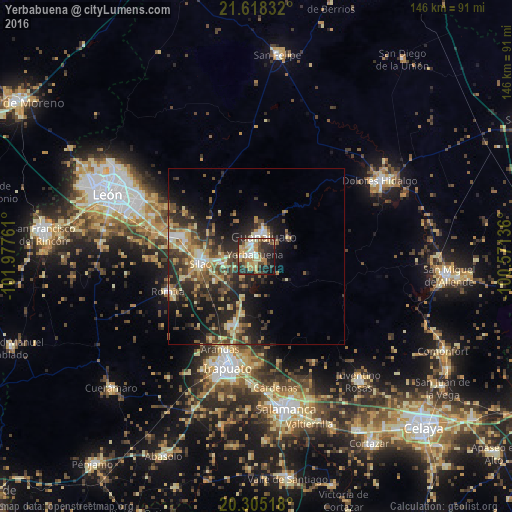
Analysis of Yerbabuena night lights 2016
Square area 10x10 km:
 4.76%
4.76%90-99
10.12%80-89
9.72%70-79
11.71%60-69
8.33%50-59
4.56%40-49
12.1%30-39
5.95%20-29
21.43%10-19
10.52%0-9
0.79%Square area 50x50 km:
1.23%90-99
2.02%80-89
3.05%70-79
2.86%60-69
2.43%50-59
2.5%40-49
4.96%30-39
3.69%20-29
7.61%10-19
10.7%0-9
58.94%Clear (daylight) street map image can be seen on geolist.org.
Map coordinates:
21° 37' 6" North, 101° 58' 39.4" West
20° 57' 47.5" North, 101° 16' 28.1" West
20° 18' 18.6" North, 100° 34' 16.9" West
Some cities around Yerbabuena sort by population:
• Silao
16 km =9.9 mi,  262°
262°
• Guanajuato
6.4 km =4 mi,  14°
14°
• Marfil
3.3 km =2.1 mi,  342°
342°
• Romita
27.2 km =16.9 mi,  247°
247°
• Arandas
28.4 km =17.6 mi,  201°
201°
• Santa Teresa
4.4 km =2.7 mi, 264°
• Duarte
29.4 km =18.3 mi,  297°
297°
• La Aldea
22.3 km =13.9 mi, 252°
3979923 (p: 8,399)
Sources (retrieved 2019-11-25):
» Earth at Night: Flat Maps 2012, 2016