Duarte night lights from space
Night Light of Duarte (Guanajuato) from space (Mexico) Src. Average luminocity for 10x10km area is 46.8214% and for 50x50km: 31.6103%.
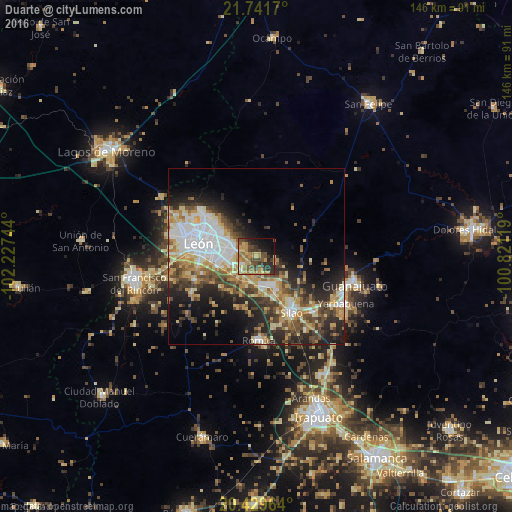
Analysis of Duarte night lights 2016
Square area 10x10 km:
 1.79%
1.79%90-99
1.19%80-89
8.53%70-79
14.48%60-69
11.9%50-59
8.33%40-49
12.1%30-39
10.32%20-29
11.11%10-19
14.48%0-9
5.75%Square area 50x50 km:
6.33%90-99
4.64%80-89
4.77%70-79
5.04%60-69
4.17%50-59
3.71%40-49
5.87%30-39
4.54%20-29
8.5%10-19
9.93%0-9
42.49%Clear (daylight) street map image can be seen on geolist.org.
Map coordinates:
21° 44' 30.1" North, 102° 13' 38.8" West
21° 5' 13.6" North, 101° 31' 27.5" West
20° 25' 46.7" North, 100° 49' 16.3" West
Some cities around Duarte sort by population:
• León de los Aldama
16.2 km =10.1 mi,  286°
286°
• Silao
18.9 km =11.7 mi,  147°
147°
• Centro Familiar la Soledad
24 km =14.9 mi,  282°
282°
• Romita
24 km =14.9 mi,  178°
178°
• La Ermita
22.8 km =14.2 mi, 288°
• Medina
12.3 km =7.6 mi,  304°
304°
• La Aldea
21.2 km =13.2 mi,  167°
167°
• Plan de Ayala
20.5 km =12.7 mi,  265°
265°
4011755 (p: 6,261)
Sources (retrieved 2019-11-25):
» Earth at Night: Flat Maps 2012, 2016