Santa Teresa night lights from space
Night Light of Santa Teresa (Guanajuato) from space (Mexico) Src. Average luminocity for 10x10km area is 57.127% and for 50x50km: 21.0914%.
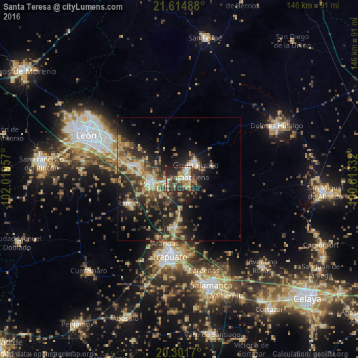
Analysis of Santa Teresa night lights 2016
Square area 10x10 km:
 5.56%
5.56%90-99
11.51%80-89
11.9%70-79
11.9%60-69
6.15%50-59
3.97%40-49
15.28%30-39
7.14%20-29
22.62%10-19
3.97%0-9
0%Square area 50x50 km:
1.31%90-99
2.16%80-89
3.58%70-79
3.54%60-69
2.99%50-59
2.92%40-49
5.62%30-39
4.34%20-29
8.35%10-19
12.38%0-9
52.8%Clear (daylight) street map image can be seen on geolist.org.
Map coordinates:
21° 36' 53.6" North, 102° 1' 10.5" West
20° 57' 35" North, 101° 18' 59.2" West
20° 18' 6.1" North, 100° 36' 48" West
Some cities around Santa Teresa sort by population:
• Silao
11.6 km =7.2 mi,  261°
261°
• Guanajuato
8.8 km =5.5 mi,  42°
42°
• Marfil
4.9 km =3 mi, 43°
• Romita
23 km =14.3 mi,  244°
244°
• Yerbabuena
4.4 km =2.7 mi,  84°
84°
• Arandas
26.8 km =16.7 mi,  192°
192°
• Duarte
25.8 km =16 mi,  303°
303°
• La Aldea
18 km =11.2 mi,  249°
249°
3983764 (p: 6,998)
Sources (retrieved 2019-11-25):
» Earth at Night: Flat Maps 2012, 2016