Yehualtepec night lights from space
Night Light of Yehualtepec (Puebla) from space (Mexico) Src. Average luminocity for 10x10km area is 17.4199% and for 50x50km: 16.1053%.
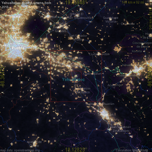
Analysis of Yehualtepec night lights 2016
Square area 10x10 km:
 0%
0%90-99
0%80-89
1.73%70-79
3.68%60-69
4.11%50-59
1.52%40-49
2.81%30-39
4.55%20-29
1.08%10-19
29.87%0-9
50.65%Square area 50x50 km:
0.14%90-99
0.49%80-89
3.16%70-79
2.4%60-69
3.71%50-59
1.92%40-49
4.53%30-39
4.88%20-29
5.3%10-19
9.79%0-9
63.7%Clear (daylight) street map image can be seen on geolist.org.
Map coordinates:
19° 27' 34.1" North, 98° 21' 53" West
18° 47' 42.6" North, 97° 39' 41.8" West
18° 7' 41.7" North, 96° 57' 30.5" West
Some cities around Yehualtepec sort by population:
• Tecamachalco
12.4 km =7.7 mi,  322°
322°
• Palmarito Tochapan
12.1 km =7.5 mi,  11°
11°
• Tlaixpan
15.3 km =9.5 mi,  328°
328°
• San Marcos Tlacoyalco
14.8 km =9.2 mi,  155°
155°
• Tlacotepec
12.6 km =7.8 mi,  177°
177°
• Xaltepec
11.1 km =6.9 mi,  30°
30°
• Santiago Alseseca
7.3 km =4.5 mi, 319°
• San Gabriel Tetzoyocán
6.1 km =3.8 mi,  226°
226°
3514272 (p: 6,903)
Sources (retrieved 2019-11-25):
» Earth at Night: Flat Maps 2012, 2016