Tlaixpan night lights from space
Night Light of Tlaixpan (Puebla) from space (Mexico) Src. Average luminocity for 10x10km area is 51.3117% and for 50x50km: 20.5823%.
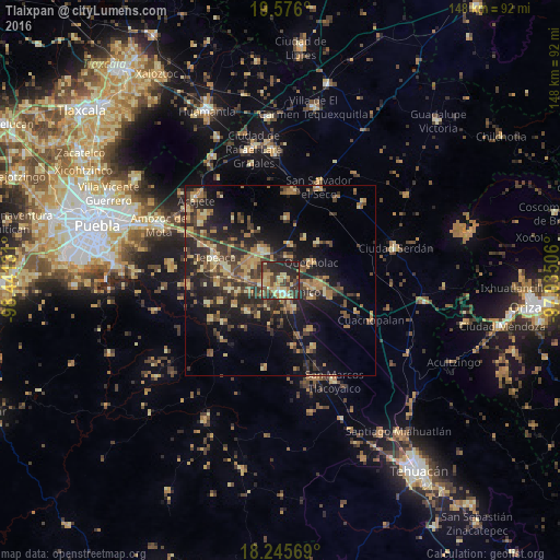
Analysis of Tlaixpan night lights 2016
Square area 10x10 km:
 2.81%
2.81%90-99
3.03%80-89
16.02%70-79
9.74%60-69
7.79%50-59
3.46%40-49
13.85%30-39
13.42%20-29
25.76%10-19
4.11%0-9
0%Square area 50x50 km:
0.19%90-99
0.69%80-89
4.24%70-79
3.23%60-69
4.57%50-59
2.12%40-49
5.5%30-39
5.86%20-29
7.85%10-19
13.35%0-9
52.4%Clear (daylight) street map image can be seen on geolist.org.
Map coordinates:
19° 34' 33.6" North, 98° 26' 28.7" West
18° 54' 43.8" North, 97° 44' 17.4" West
18° 14' 44.5" North, 97° 2' 6.2" West
Some cities around Tlaixpan sort by population:
• Tecamachalco
3.2 km =2 mi,  171°
171°
• Acatzingo
9.1 km =5.7 mi,  328°
328°
• Los Reyes de Juárez
8 km =5 mi,  300°
300°
• Huixcolotla
3.6 km =2.2 mi,  285°
285°
• Santiago Alseseca
8.1 km =5 mi,  156°
156°
• Actipan de Morelos
8.3 km =5.2 mi,  309°
309°
• Cuapiaxtla de Madero
9 km =5.6 mi,  272°
272°
• San Martín Caltenco
9 km =5.6 mi,  250°
250°
3518363 (p: 10,513)
Sources (retrieved 2019-11-25):
» Earth at Night: Flat Maps 2012, 2016