Tlacotepec night lights from space
Night Light of Tlacotepec (Puebla) from space (Mexico) Src. Average luminocity for 10x10km area is 22.4153% and for 50x50km: 12.0326%.
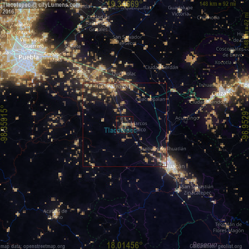
Analysis of Tlacotepec night lights 2016
Square area 10x10 km:
 0%
0%90-99
0%80-89
1.24%70-79
0.41%60-69
7.02%50-59
4.96%40-49
6.82%30-39
11.36%20-29
4.75%10-19
24.79%0-9
38.64%Square area 50x50 km:
0.17%90-99
0.4%80-89
1.97%70-79
1.49%60-69
2.86%50-59
1.75%40-49
3.11%30-39
3.51%20-29
3.75%10-19
8.15%0-9
72.83%Clear (daylight) street map image can be seen on geolist.org.
Map coordinates:
19° 20' 48.1" North, 98° 21' 32.9" West
18° 40' 54.9" North, 97° 39' 21.7" West
18° 0' 52.4" North, 96° 57' 10.4" West
Some cities around Tlacotepec sort by population:
• San Marcos Tlacoyalco
5.6 km =3.5 mi,  99°
99°
• Xaltepec
22.8 km =14.2 mi,  12°
12°
• Cuacnopalan
21.5 km =13.4 mi,  45°
45°
• Santiago Alseseca
18.9 km =11.7 mi,  343°
343°
• Yehualtepec
12.6 km =7.8 mi,  357°
357°
• Santa María la Alta
9.1 km =5.7 mi,  181°
181°
• San Gabriel Tetzoyocán
9.7 km =6 mi,  329°
329°
• Xochitlan Todos Santos
12.9 km =8 mi,  280°
280°
3515476 (p: 8,908)
Sources (retrieved 2019-11-25):
» Earth at Night: Flat Maps 2012, 2016