Xaloztoc night lights from space
Night Light of Xaloztoc (Tlaxcala) from space (Mexico) Src. Average luminocity for 10x10km area is 48.6839% and for 50x50km: 26.8263%.
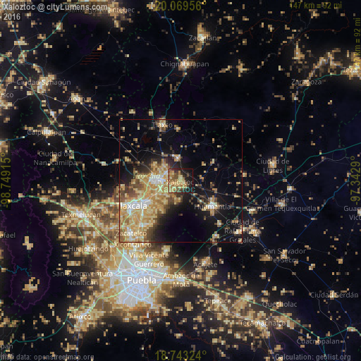
Analysis of Xaloztoc night lights 2016
Square area 10x10 km:
 0%
0%90-99
0.62%80-89
16.74%70-79
14.46%60-69
10.54%50-59
8.06%40-49
9.3%30-39
6.82%20-29
10.12%10-19
20.87%0-9
2.48%Square area 50x50 km:
1.59%90-99
2.69%80-89
7.36%70-79
6%60-69
4.61%50-59
3.03%40-49
4.51%30-39
3.06%20-29
4.35%10-19
12.57%0-9
50.22%Clear (daylight) street map image can be seen on geolist.org.
Map coordinates:
20° 4' 10.4" North, 98° 44' 56.9" West
19° 24' 27.9" North, 98° 2' 45.7" West
18° 44' 35.7" North, 97° 20' 34.4" West
Some cities around Xaloztoc sort by population:
• Apizaco
10.2 km =6.3 mi,  273°
273°
• Tetla
7.1 km =4.4 mi,  302°
302°
• San Andrés Ahuashuatepec
7.1 km =4.4 mi,  242°
242°
• Santa María Texcalac
4.6 km =2.9 mi,  292°
292°
• San Luis Apizaquito
7.7 km =4.8 mi,  284°
284°
• San Miguel Contla
10.4 km =6.5 mi, 240°
• Tocatlán
2.9 km =1.8 mi,  137°
137°
• San José Teacalco
8.3 km =5.2 mi,  193°
193°
3514595 (p: 10,191)
Sources (retrieved 2019-11-25):
» Earth at Night: Flat Maps 2012, 2016