San José Teacalco night lights from space
Night Light of San José Teacalco (Tlaxcala) from space (Mexico) Src. Average luminocity for 10x10km area is 37.6012% and for 50x50km: 32.7792%.
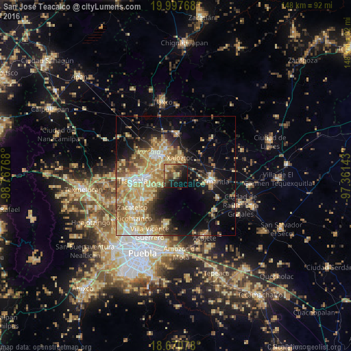
Analysis of San José Teacalco night lights 2016
Square area 10x10 km:
 0%
0%90-99
0.21%80-89
10.54%70-79
7.02%60-69
5.79%50-59
5.58%40-49
15.08%30-39
9.3%20-29
12.19%10-19
21.9%0-9
12.4%Square area 50x50 km:
2.27%90-99
3.74%80-89
9.39%70-79
7.07%60-69
5.52%50-59
3.85%40-49
5.35%30-39
3.43%20-29
4.73%10-19
13.61%0-9
41.03%Clear (daylight) street map image can be seen on geolist.org.
Map coordinates:
19° 59' 51.6" North, 98° 46' 3.6" West
19° 20' 8.1" North, 98° 3' 52.4" West
18° 40' 14.8" North, 97° 21' 41.1" West
Some cities around San José Teacalco sort by population:
• Contla
10.7 km =6.6 mi,  266°
266°
• Xaloztoc
8.3 km =5.2 mi,  13°
13°
• San Andrés Ahuashuatepec
6.5 km =4 mi,  317°
317°
• Amaxac de Guerrero
11.2 km =7 mi,  276°
276°
• Santa Anita Huiloac
10.2 km =6.3 mi,  305°
305°
• Santa María Texcalac
10 km =6.2 mi,  346°
346°
• San Miguel Contla
7.7 km =4.8 mi,  291°
291°
• Tocatlán
7.1 km =4.4 mi,  33°
33°
3815199 (p: 5,381)
Sources (retrieved 2019-11-25):
» Earth at Night: Flat Maps 2012, 2016