Xalatlaco night lights from space
Night Light of Xalatlaco (México) from space (Mexico) Src. Average luminocity for 10x10km area is 50.7035% and for 50x50km: 44.3633%.
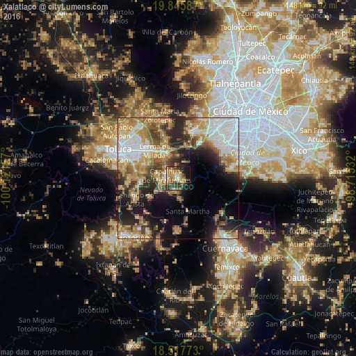
Analysis of Xalatlaco night lights 2016
Square area 10x10 km:
 1.52%
1.52%90-99
6.06%80-89
10.82%70-79
10.17%60-69
16.67%50-59
4.98%40-49
9.74%30-39
11.47%20-29
8.87%10-19
18.61%0-9
1.08%Square area 50x50 km:
10.06%90-99
5.87%80-89
7.49%70-79
7.83%60-69
8.29%50-59
4.35%40-49
5.5%30-39
5.03%20-29
8.68%10-19
11.69%0-9
25.21%Clear (daylight) street map image can be seen on geolist.org.
Map coordinates:
19° 50' 45.1" North, 100° 7' 17.7" West
19° 10' 59.3" North, 99° 25' 6.4" West
18° 31' 3.8" North, 98° 42' 55.2" West
Some cities around Xalatlaco sort by population:
• Ocoyoacac
10.6 km =6.6 mi,  337°
337°
• Capulhuac de Mirafuentes
5.1 km =3.2 mi,  283°
283°
• Santiago Tianguistenco de Galeana
5.1 km =3.2 mi,  266°
266°
• San Pedro Tlaltizapan
8.7 km =5.4 mi, 282°
• Santiago Tílapa
0.8 km =0.5 mi, 340°
• Almoloya del Río
7.7 km =4.8 mi,  250°
250°
• Santa Cruz Atizapán
7.4 km =4.6 mi,  264°
264°
• San Nicolás Coatepec
5.2 km =3.2 mi,  192°
192°
3526611 (p: 15,043)
Sources (retrieved 2019-11-25):
» Earth at Night: Flat Maps 2012, 2016