Santa Cruz Atizapán night lights from space
Night Light of Santa Cruz Atizapán (México) from space (Mexico) Src. Average luminocity for 10x10km area is 57.1818% and for 50x50km: 43.3523%.
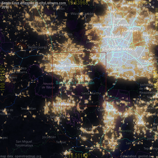
Analysis of Santa Cruz Atizapán night lights 2016
Square area 10x10 km:
 3.25%
3.25%90-99
5.41%80-89
13.2%70-79
12.12%60-69
13.85%50-59
9.09%40-49
12.77%30-39
12.34%20-29
17.53%10-19
0.43%0-9
0%Square area 50x50 km:
6.81%90-99
6.03%80-89
8.29%70-79
8.64%60-69
9.17%50-59
4.68%40-49
5.51%30-39
4.95%20-29
8.68%10-19
12.1%0-9
25.15%Clear (daylight) street map image can be seen on geolist.org.
Map coordinates:
19° 50' 22.8" North, 100° 11' 29.9" West
19° 10' 36.9" North, 99° 29' 18.7" West
18° 30' 41.4" North, 98° 47' 7.4" West
Some cities around Santa Cruz Atizapán sort by population:
• Capulhuac de Mirafuentes
3 km =1.9 mi,  52°
52°
• Xalatlaco
7.4 km =4.6 mi,  84°
84°
• Santiago Tianguistenco de Galeana
2.3 km =1.4 mi, 80°
• San Pedro Tlaltizapan
2.8 km =1.7 mi,  335°
335°
• Santiago Tílapa
7.2 km =4.5 mi, 78°
• Almoloya del Río
1.8 km =1.1 mi,  176°
176°
• Ex-Rancho San Dimas
8.1 km =5 mi,  267°
267°
• San Nicolás Coatepec
7.6 km =4.7 mi,  125°
125°
3817592 (p: 8,062)
Sources (retrieved 2019-11-25):
» Earth at Night: Flat Maps 2012, 2016