Santiago Tianguistenco de Galeana night lights from space
Night Light of Santiago Tianguistenco de Galeana (México) from space (Mexico) Src. Average luminocity for 10x10km area is 64.3593% and for 50x50km: 43.9442%.
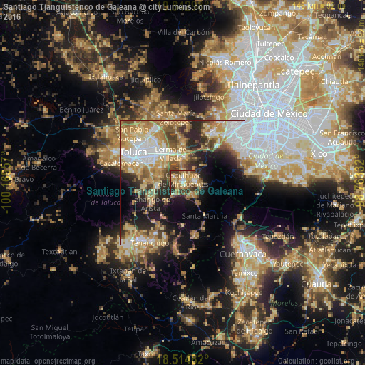
Analysis of Santiago Tianguistenco de Galeana night lights 2016
Square area 10x10 km:
 3.68%
3.68%90-99
7.36%80-89
16.88%70-79
16.45%60-69
17.53%50-59
8.66%40-49
11.9%30-39
11.04%20-29
6.49%10-19
0%0-9
0%Square area 50x50 km:
7.86%90-99
6.14%80-89
8.1%70-79
8.4%60-69
8.76%50-59
4.64%40-49
5.55%30-39
5.12%20-29
8.61%10-19
12.03%0-9
24.78%Clear (daylight) street map image can be seen on geolist.org.
Map coordinates:
19° 50' 34.7" North, 100° 10' 10.5" West
19° 10' 48.9" North, 99° 27' 59.2" West
18° 30' 53.4" North, 98° 45' 48" West
Some cities around Santiago Tianguistenco de Galeana sort by population:
• Capulhuac de Mirafuentes
1.5 km =0.9 mi,  2°
2°
• Xalatlaco
5.1 km =3.2 mi,  86°
86°
• San Pedro Tlaltizapan
4.1 km =2.5 mi,  301°
301°
• Almoloya del Río
3.1 km =1.9 mi,  225°
225°
• San Pedro Cholula
9.6 km =6 mi,  347°
347°
• San Pedro Chochula
9.5 km =5.9 mi, 347°
• Santa Cruz Atizapán
2.3 km =1.4 mi,  260°
260°
• San Nicolás Coatepec
6.1 km =3.8 mi,  140°
140°
3515679 (p: 13,106)
Sources (retrieved 2019-11-25):
» Earth at Night: Flat Maps 2012, 2016