Almoloya del Río night lights from space
Night Light of Almoloya del Río (México) from space (Mexico) Src. Average luminocity for 10x10km area is 54.1667% and for 50x50km: 42.3132%.
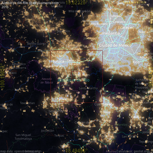
Analysis of Almoloya del Río night lights 2016
Square area 10x10 km:
 3.46%
3.46%90-99
5.19%80-89
11.9%70-79
11.47%60-69
14.94%50-59
6.71%40-49
9.96%30-39
8.23%20-29
21.21%10-19
6.93%0-9
0%Square area 50x50 km:
6.57%90-99
6.11%80-89
8.44%70-79
8.35%60-69
7.96%50-59
4.45%40-49
5.51%30-39
5.09%20-29
8.58%10-19
12.64%0-9
26.32%Clear (daylight) street map image can be seen on geolist.org.
Map coordinates:
19° 49' 23.8" North, 100° 11' 25.9" West
19° 9' 37.7" North, 99° 29' 14.6" West
18° 29' 41.9" North, 98° 47' 3.4" West
Some cities around Almoloya del Río sort by population:
• Capulhuac de Mirafuentes
4.3 km =2.7 mi,  31°
31°
• Xalatlaco
7.7 km =4.8 mi,  70°
70°
• Santiago Tianguistenco de Galeana
3.1 km =1.9 mi,  45°
45°
• San Pedro Tlaltizapan
4.5 km =2.8 mi,  343°
343°
• Santiago Tílapa
7.7 km =4.8 mi, 65°
• Santa Cruz Atizapán
1.8 km =1.1 mi,  356°
356°
• San Nicolás Coatepec
6.6 km =4.1 mi,  112°
112°
• Santa María Jajalpa
7.4 km =4.6 mi,  223°
223°
3533037 (p: 9,507)
Sources (retrieved 2019-11-25):
» Earth at Night: Flat Maps 2012, 2016