Villa de Reyes night lights from space
Night Light of Villa de Reyes (San Luis Potosí) from space (Mexico) Src. Average luminocity for 10x10km area is 13.502% and for 50x50km: 4.2948%.
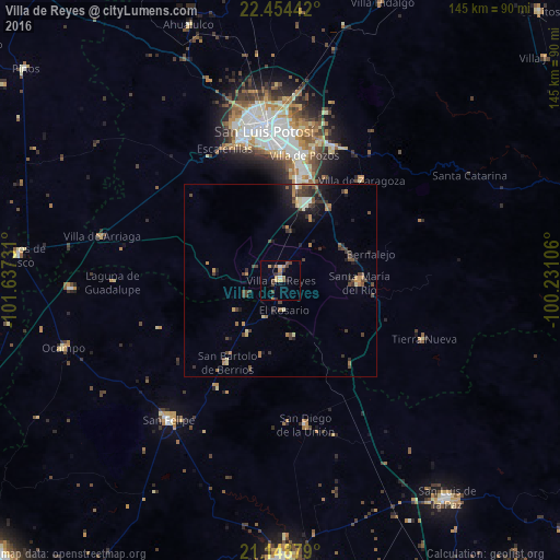
Analysis of Villa de Reyes night lights 2016
Square area 10x10 km:
 0.79%
0.79%90-99
0.79%80-89
1.19%70-79
3.37%60-69
2.18%50-59
2.58%40-49
2.58%30-39
2.18%20-29
2.58%10-19
1.59%0-9
80.16%Square area 50x50 km:
0.23%90-99
0.2%80-89
0.44%70-79
0.65%60-69
0.74%50-59
0.46%40-49
1.44%30-39
1.08%20-29
1.09%10-19
2.18%0-9
91.48%Clear (daylight) street map image can be seen on geolist.org.
Map coordinates:
22° 27' 15.9" North, 101° 38' 14.3" West
21° 48' 11.1" North, 100° 56' 3" West
21° 8' 55.6" North, 100° 13' 51.8" West
Some cities around Villa de Reyes sort by population:
• San Luis Potosí
38.8 km =24.1 mi,  353°
353°
• Soledad de Graciano Sánchez
42.9 km =26.7 mi,  359°
359°
• San Felipe
46.4 km =28.8 mi,  218°
218°
• Santa María del Río
20.3 km =12.6 mi,  92°
92°
• San Diego de la Unión
37.8 km =23.5 mi,  170°
170°
• La Pila
26.6 km =16.5 mi,  14°
14°
• San Bartolo de Berrios
25.3 km =15.7 mi,  213°
213°
• Tierra Nueva
40.2 km =25 mi,  111°
111°
3980186 (p: 10,383)
Sources (retrieved 2019-11-25):
» Earth at Night: Flat Maps 2012, 2016