Villa de Etla night lights from space
Night Light of Villa de Etla (Oaxaca) from space (Mexico) Src. Average luminocity for 10x10km area is 47.5661% and for 50x50km: 14.245%.
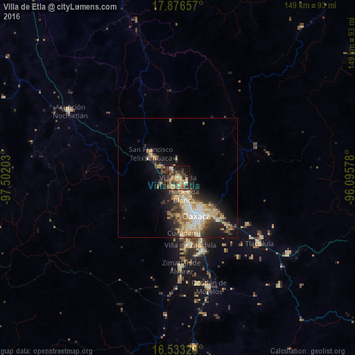
Analysis of Villa de Etla night lights 2016
Square area 10x10 km:
 0%
0%90-99
4.13%80-89
10.33%70-79
15.08%60-69
10.33%50-59
4.55%40-49
10.33%30-39
13.02%20-29
12.19%10-19
16.12%0-9
3.93%Square area 50x50 km:
1.28%90-99
2.36%80-89
2.46%70-79
2.86%60-69
2.31%50-59
1.35%40-49
2.63%30-39
2.13%20-29
3.3%10-19
7.39%0-9
71.92%Clear (daylight) street map image can be seen on geolist.org.
Map coordinates:
17° 52' 35.7" North, 97° 30' 7.3" West
17° 12' 22.1" North, 96° 47' 56" West
16° 31' 59.8" North, 96° 5' 44.8" West
Some cities around Villa de Etla sort by population:
• Oaxaca
17.6 km =10.9 mi,  152°
152°
• Santa María Atzompa
11.9 km =7.4 mi,  168°
168°
• San Jacinto Amilpas
12.2 km =7.6 mi,  161°
161°
• San Francisco Telixtlahuaca
15.1 km =9.4 mi,  311°
311°
• Hacienda Blanca
7.8 km =4.8 mi, 161°
• San Lorenzo Cacaotepec
8.7 km =5.4 mi,  182°
182°
• Santiago Suchilquitongo
9.9 km =6.2 mi,  301°
301°
• San Pablo Huitzo
12.2 km =7.6 mi, 310°
3517937 (p: 7,285)
Sources (retrieved 2019-11-25):
» Earth at Night: Flat Maps 2012, 2016