San Lorenzo Cacaotepec night lights from space
Night Light of San Lorenzo Cacaotepec (Oaxaca) from space (Mexico) Src. Average luminocity for 10x10km area is 51.5693% and for 50x50km: 16.7512%.
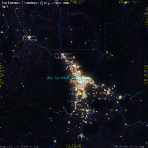
Analysis of San Lorenzo Cacaotepec night lights 2016
Square area 10x10 km:
 3.03%
3.03%90-99
11.47%80-89
7.14%70-79
12.55%60-69
10.17%50-59
3.68%40-49
9.74%30-39
11.9%20-29
11.69%10-19
17.75%0-9
0.87%Square area 50x50 km:
1.39%90-99
2.65%80-89
2.94%70-79
3.24%60-69
2.59%50-59
1.63%40-49
3.25%30-39
2.7%20-29
4.2%10-19
9.02%0-9
66.38%Clear (daylight) street map image can be seen on geolist.org.
Map coordinates:
17° 47' 54.4" North, 97° 30' 20.1" West
17° 7' 39.9" North, 96° 48' 8.8" West
16° 27' 16.6" North, 96° 5' 57.6" West
Some cities around San Lorenzo Cacaotepec sort by population:
• Oaxaca
10.9 km =6.8 mi,  129°
129°
• Santa Cruz Xoxocotlán
13 km =8.1 mi,  146°
146°
• Santa María Atzompa
4 km =2.5 mi,  136°
136°
• San Jacinto Amilpas
5.1 km =3.2 mi,  123°
123°
• El Rosario
15.1 km =9.4 mi, 128°
• Santa Cruz Amilpas
14.8 km =9.2 mi, 121°
• Hacienda Blanca
3.1 km =1.9 mi,  64°
64°
• Villa de Etla
8.7 km =5.4 mi,  2°
2°
3531875 (p: 7,351)
Sources (retrieved 2019-11-25):
» Earth at Night: Flat Maps 2012, 2016