San Jacinto Amilpas night lights from space
Night Light of San Jacinto Amilpas (Oaxaca) from space (Mexico) Src. Average luminocity for 10x10km area is 74.0216% and for 50x50km: 17.546%.
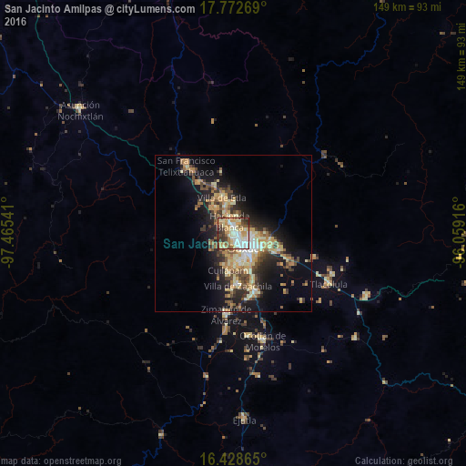
Analysis of San Jacinto Amilpas night lights 2016
Square area 10x10 km:
 15.8%
15.8%90-99
20.35%80-89
13.42%70-79
14.5%60-69
8.44%50-59
5.84%40-49
9.09%30-39
8.87%20-29
3.68%10-19
0%0-9
0%Square area 50x50 km:
1.39%90-99
2.66%80-89
3.03%70-79
3.45%60-69
2.61%50-59
1.78%40-49
3.47%30-39
2.77%20-29
4.27%10-19
10.07%0-9
64.52%Clear (daylight) street map image can be seen on geolist.org.
Map coordinates:
17° 46' 21.7" North, 97° 27' 55.5" West
17° 6' 6.8" North, 96° 45' 44.2" West
16° 25' 43.1" North, 96° 3' 33" West
Some cities around San Jacinto Amilpas sort by population:
• Oaxaca
5.8 km =3.6 mi,  134°
134°
• Santa Cruz Xoxocotlán
8.5 km =5.3 mi,  160°
160°
• Santa María Atzompa
1.5 km =0.9 mi,  269°
269°
• San Antonio de la Cal
10.4 km =6.5 mi,  141°
141°
• El Rosario
9.9 km =6.2 mi, 131°
• Santa Cruz Amilpas
9.7 km =6 mi,  119°
119°
• Hacienda Blanca
4.5 km =2.8 mi,  341°
341°
• San Lorenzo Cacaotepec
5.1 km =3.2 mi,  303°
303°
3801595 (p: 13,860)
Sources (retrieved 2019-11-25):
» Earth at Night: Flat Maps 2012, 2016