San Francisco Telixtlahuaca night lights from space
Night Light of San Francisco Telixtlahuaca (Oaxaca) from space (Mexico) Src. Average luminocity for 10x10km area is 16.7231% and for 50x50km: 7.6801%.
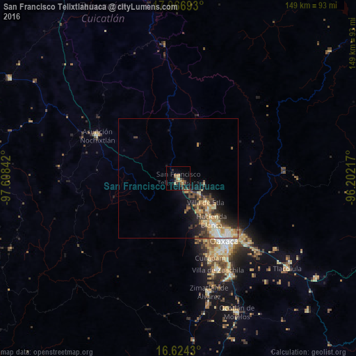
Analysis of San Francisco Telixtlahuaca night lights 2016
Square area 10x10 km:
 0%
0%90-99
0.41%80-89
1.65%70-79
2.69%60-69
6.61%50-59
2.69%40-49
2.89%30-39
4.13%20-29
2.69%10-19
8.26%0-9
67.98%Square area 50x50 km:
0.57%90-99
1.19%80-89
1.11%70-79
1.61%60-69
1.27%50-59
0.72%40-49
1.41%30-39
1.57%20-29
1.85%10-19
4.49%0-9
84.2%Clear (daylight) street map image can be seen on geolist.org.
Map coordinates:
17° 58' 0.9" North, 97° 36' 30.3" West
17° 17' 48.6" North, 96° 54' 19" West
16° 37' 27.5" North, 96° 12' 7.8" West
Some cities around San Francisco Telixtlahuaca sort by population:
• Oaxaca
32.2 km =20 mi,  143°
143°
• Santa María Atzompa
25.6 km =15.9 mi,  147°
147°
• San Jacinto Amilpas
26.5 km =16.5 mi, 144°
• Hacienda Blanca
22.2 km =13.8 mi, 141°
• San Lorenzo Cacaotepec
21.7 km =13.5 mi, 149°
• Villa de Etla
15.1 km =9.4 mi,  131°
131°
• Santiago Suchilquitongo
5.6 km =3.5 mi, 149°
• San Pablo Huitzo
3 km =1.9 mi, 137°
3519255 (p: 10,618)
Sources (retrieved 2019-11-25):
» Earth at Night: Flat Maps 2012, 2016