Hacienda Blanca night lights from space
Night Light of Hacienda Blanca (Oaxaca) from space (Mexico) Src. Average luminocity for 10x10km area is 61.4784% and for 50x50km: 16.6593%.
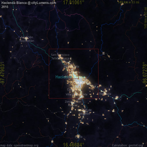
Analysis of Hacienda Blanca night lights 2016
Square area 10x10 km:
 3.25%
3.25%90-99
14.5%80-89
11.9%70-79
15.58%60-69
12.12%50-59
4.76%40-49
12.99%30-39
9.74%20-29
12.34%10-19
2.81%0-9
0%Square area 50x50 km:
1.38%90-99
2.63%80-89
2.96%70-79
3.24%60-69
2.59%50-59
1.57%40-49
3.27%30-39
2.62%20-29
4.05%10-19
8.62%0-9
67.06%Clear (daylight) street map image can be seen on geolist.org.
Map coordinates:
17° 48' 38.2" North, 97° 28' 44.5" West
17° 8' 23.8" North, 96° 46' 33.2" West
16° 28' 0.6" North, 96° 4' 22" West
Some cities around Hacienda Blanca sort by population:
• Oaxaca
10 km =6.2 mi,  146°
146°
• Santa Cruz Xoxocotlán
13 km =8.1 mi,  160°
160°
• Santa María Atzompa
4.3 km =2.7 mi,  181°
181°
• San Jacinto Amilpas
4.5 km =2.8 mi, 161°
• El Rosario
14 km =8.7 mi,  140°
140°
• Santa Cruz Amilpas
13.4 km =8.3 mi,  132°
132°
• San Lorenzo Cacaotepec
3.1 km =1.9 mi,  244°
244°
• Villa de Etla
7.8 km =4.8 mi,  341°
341°
3527179 (p: 7,758)
Sources (retrieved 2019-11-25):
» Earth at Night: Flat Maps 2012, 2016