La Pastoría night lights from space
Night Light of La Pastoría (México) from space (Mexico) Src. Average luminocity for 10x10km area is 86.2769% and for 50x50km: 67.1959%.
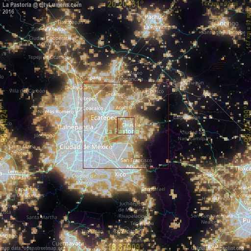
Analysis of La Pastoría night lights 2016
Square area 10x10 km:
 23.55%
90-99
24.38%80-89
19.63%70-79
17.98%60-69
13.84%50-59
0.62%40-49
0%30-39
0%20-29
0%10-19
0%0-9
0%Square area 50x50 km:
25.38%90-99
11.1%80-89
11.97%70-79
11.35%60-69
8.03%50-59
5.04%40-49
3.88%30-39
2.21%20-29
4.02%10-19
5.22%0-9
11.78%Clear (daylight) street map image can be seen on geolist.org.
Map coordinates:
20° 12' 15.5" North, 99° 36' 51.3" West
19° 32' 35" North, 98° 54' 40" West
18° 52' 44.7" North, 98° 12' 28.8" West
Some cities around La Pastoría sort by population:
• Texcoco de Mora
4.5 km =2.8 mi,  139°
139°
• Chiconcuac
2.2 km =1.4 mi,  35°
35°
• San Salvador Atenco
1.2 km =0.7 mi,  320°
320°
• Tezoyuca
5.5 km =3.4 mi,  0°
0°
• Tulantongo
4 km =2.5 mi,  108°
108°
• Chiautla
3.1 km =1.9 mi,  77°
77°
• San Cristóbal Nexquipayac
4.6 km =2.9 mi,  333°
333°
• Tequisistlán
6.7 km =4.2 mi, 332°
8858264 (p: 5,135)
Sources (retrieved 2019-11-25):
» Earth at Night: Flat Maps 2012, 2016