San Salvador Atenco night lights from space
Night Light of San Salvador Atenco (México) from space (Mexico) Src. Average luminocity for 10x10km area is 84.5289% and for 50x50km: 68.4502%.
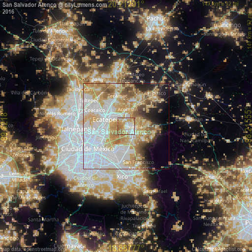
Analysis of San Salvador Atenco night lights 2016
Square area 10x10 km:
 21.28%
90-99
22.52%80-89
17.56%70-79
19.63%60-69
18.39%50-59
0.62%40-49
0%30-39
0%20-29
0%10-19
0%0-9
0%Square area 50x50 km:
25.89%90-99
11.17%80-89
12.15%70-79
11.7%60-69
8.35%50-59
5.11%40-49
3.92%30-39
2.26%20-29
4.04%10-19
5.47%0-9
9.95%Clear (daylight) street map image can be seen on geolist.org.
Map coordinates:
20° 12' 46.5" North, 99° 37' 18.5" West
19° 33' 6.1" North, 98° 55' 7.2" West
18° 53' 16" North, 98° 12' 56" West
Some cities around San Salvador Atenco sort by population:
• Texcoco de Mora
5.8 km =3.6 mi,  139°
139°
• Chiconcuac
2.2 km =1.4 mi,  67°
67°
• Tezoyuca
4.6 km =2.9 mi,  10°
10°
• Tulantongo
5.1 km =3.2 mi,  115°
115°
• Chiautla
3.8 km =2.4 mi,  94°
94°
• San Cristóbal Nexquipayac
3.4 km =2.1 mi,  338°
338°
• Tequisistlán
5.5 km =3.4 mi,  334°
334°
• La Pastoría
1.2 km =0.7 mi, 140°
3517832 (p: 17,124)
Sources (retrieved 2019-11-25):
» Earth at Night: Flat Maps 2012, 2016