Tres Valles night lights from space
Night Light of Tres Valles (Veracruz) from space (Mexico) Src. Average luminocity for 10x10km area is 18.6948% and for 50x50km: 6.013%.
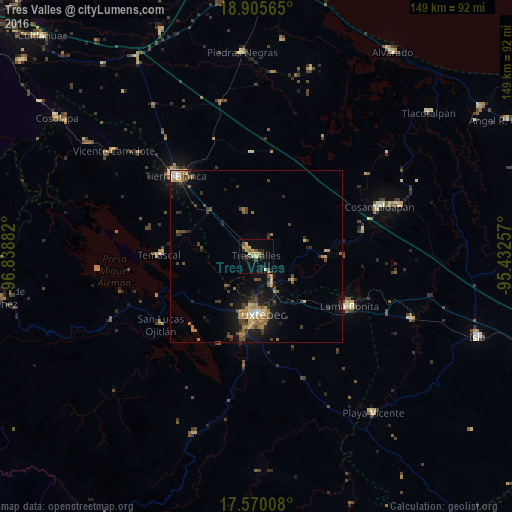
Analysis of Tres Valles night lights 2016
Square area 10x10 km:
 0%
0%90-99
1.73%80-89
1.95%70-79
5.84%60-69
3.03%50-59
2.38%40-49
3.9%30-39
2.6%20-29
3.68%10-19
3.9%0-9
71%Square area 50x50 km:
0.19%90-99
0.43%80-89
0.77%70-79
1.04%60-69
1.27%50-59
0.71%40-49
1.41%30-39
1.2%20-29
1.56%10-19
3.58%0-9
87.85%Clear (daylight) street map image can be seen on geolist.org.
Map coordinates:
18° 54' 20.3" North, 96° 50' 19.8" West
18° 14' 20.9" North, 96° 8' 8.5" West
17° 34' 12.3" North, 95° 25' 57.3" West
Some cities around Tres Valles sort by population:
• Tuxtepec
16.8 km =10.4 mi,  176°
176°
• Tierra Blanca
33.1 km =20.6 mi,  314°
314°
• Loma Bonita
30.8 km =19.1 mi,  118°
118°
• Cosamaloapan
38.3 km =23.8 mi,  68°
68°
• La Isla
40.2 km =25 mi,  357°
357°
• Isla Soyaltepec
37 km =23 mi,  263°
263°
• Temascal
28.1 km =17.5 mi,  270°
270°
• San Lucas Ojitlán
34.3 km =21.3 mi,  233°
233°
11839902 (p: 17,299)
Sources (retrieved 2019-11-25):
» Earth at Night: Flat Maps 2012, 2016