San Matías Cuijingo night lights from space
Night Light of San Matías Cuijingo (México) from space (Mexico) Src. Average luminocity for 10x10km area is 21.2554% and for 50x50km: 34.1792%.
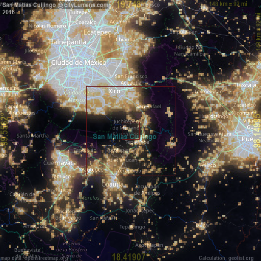
Analysis of San Matías Cuijingo night lights 2016
Square area 10x10 km:
 1.08%
1.08%90-99
1.08%80-89
2.6%70-79
2.38%60-69
1.3%50-59
1.95%40-49
3.46%30-39
1.73%20-29
12.55%10-19
46.54%0-9
25.32%Square area 50x50 km:
4.04%90-99
4.57%80-89
7.12%70-79
7.28%60-69
6.12%50-59
3.16%40-49
5.08%30-39
3.89%20-29
7.96%10-19
14.38%0-9
36.4%Clear (daylight) street map image can be seen on geolist.org.
Map coordinates:
19° 44' 52.8" North, 99° 33' 22.3" West
19° 5' 5.5" North, 98° 51' 11.1" West
18° 25' 8.7" North, 98° 8' 59.8" West
Some cities around San Matías Cuijingo sort by population:
• Amecameca
10.1 km =6.3 mi,  64°
64°
• Ozumba de Alzate
8.1 km =5 mi,  131°
131°
• Juchitepec
3.2 km =2 mi,  302°
302°
• Tepetlixpa
7.1 km =4.4 mi,  151°
151°
• Atlautla
10.5 km =6.5 mi, 131°
• San Juan Tehuixtitlán
9.6 km =6 mi,  110°
110°
• Ayapango
7.3 km =4.5 mi,  50°
50°
• Tenango del Aire
8.1 km =5 mi,  357°
357°
3817616 (p: 6,263)
Sources (retrieved 2019-11-25):
» Earth at Night: Flat Maps 2012, 2016