Tochtepec night lights from space
Night Light of Tochtepec (Puebla) from space (Mexico) Src. Average luminocity for 10x10km area is 31.6948% and for 50x50km: 21.9798%.
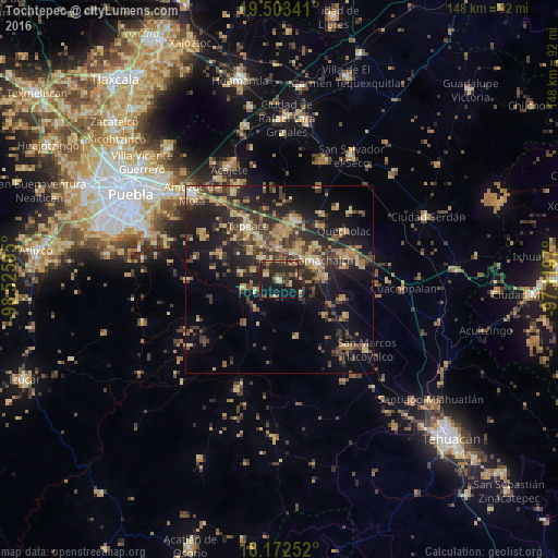
Analysis of Tochtepec night lights 2016
Square area 10x10 km:
 0%
0%90-99
1.08%80-89
6.28%70-79
3.03%60-69
6.28%50-59
3.03%40-49
7.36%30-39
11.04%20-29
22.73%10-19
31.17%0-9
8.01%Square area 50x50 km:
0.27%90-99
0.76%80-89
4.71%70-79
3.45%60-69
4.34%50-59
2.23%40-49
5.69%30-39
6.72%20-29
8.25%10-19
15.91%0-9
47.66%Clear (daylight) street map image can be seen on geolist.org.
Map coordinates:
19° 30' 12.3" North, 98° 31' 33.4" West
18° 50' 21.4" North, 97° 49' 22.2" West
18° 10' 21.1" North, 97° 7' 10.9" West
Some cities around Tochtepec sort by population:
• Tecamachalco
10.6 km =6.6 mi,  62°
62°
• Huixcolotla
10.5 km =6.5 mi,  30°
30°
• Tlaixpan
12 km =7.5 mi,  47°
47°
• Santiago Alseseca
12.2 km =7.6 mi,  86°
86°
• Cuapiaxtla de Madero
8.5 km =5.3 mi,  359°
359°
• Atoyatempan
9.8 km =6.1 mi,  256°
256°
• Hueyotlipan
7.4 km =4.6 mi,  322°
322°
• San Martín Caltenco
5.1 km =3.2 mi,  4°
4°
3515330 (p: 6,615)
Sources (retrieved 2019-11-25):
» Earth at Night: Flat Maps 2012, 2016