Atoyatempan night lights from space
Night Light of Atoyatempan (Puebla) from space (Mexico) Src. Average luminocity for 10x10km area is 22.6255% and for 50x50km: 21.1109%.
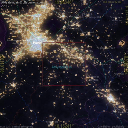
Analysis of Atoyatempan night lights 2016
Square area 10x10 km:
 0%
0%90-99
1.73%80-89
6.49%70-79
2.16%60-69
2.16%50-59
2.16%40-49
4.76%30-39
4.33%20-29
8.87%10-19
25.97%0-9
41.34%Square area 50x50 km:
0.39%90-99
0.8%80-89
4.85%70-79
3.3%60-69
3.84%50-59
2.34%40-49
5.38%30-39
6.57%20-29
8.2%10-19
13.36%0-9
50.99%Clear (daylight) street map image can be seen on geolist.org.
Map coordinates:
19° 29' 0.5" North, 98° 37' 1.3" West
18° 49' 9.3" North, 97° 54' 50" West
18° 9' 8.7" North, 97° 12' 38.8" West
Some cities around Atoyatempan sort by population:
• Tepeaca
16.5 km =10.3 mi,  5°
5°
• Los Reyes de Juárez
18.5 km =11.5 mi,  38°
38°
• San Hipólito
14.2 km =8.8 mi,  17°
17°
• Cuapiaxtla de Madero
14.3 km =8.9 mi, 41°
• Tochtepec
9.8 km =6.1 mi,  76°
76°
• Hueyotlipan
9.5 km =5.9 mi,  32°
32°
• Tecali
10.8 km =6.7 mi,  326°
326°
• San Martín Caltenco
12.4 km =7.7 mi,  53°
53°
3532569 (p: 6,154)
Sources (retrieved 2019-11-25):
» Earth at Night: Flat Maps 2012, 2016