San Martín Caltenco night lights from space
Night Light of San Martín Caltenco (Puebla) from space (Mexico) Src. Average luminocity for 10x10km area is 49.3333% and for 50x50km: 23.0212%.
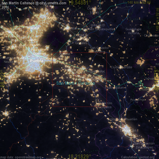
Analysis of San Martín Caltenco night lights 2016
Square area 10x10 km:
 0%
0%90-99
1.52%80-89
13.42%70-79
7.14%60-69
11.69%50-59
7.36%40-49
18.18%30-39
18.4%20-29
20.56%10-19
1.73%0-9
0%Square area 50x50 km:
0.28%90-99
0.8%80-89
4.89%70-79
3.51%60-69
4.54%50-59
2.37%40-49
6.06%30-39
7.02%20-29
9.11%10-19
16.49%0-9
44.93%Clear (daylight) street map image can be seen on geolist.org.
Map coordinates:
19° 32' 55.7" North, 98° 31' 19.2" West
18° 53' 5.5" North, 97° 49' 7.9" West
18° 13' 5.8" North, 97° 6' 56.7" West
Some cities around San Martín Caltenco sort by population:
• Los Reyes de Juárez
7.3 km =4.5 mi,  12°
12°
• Huixcolotla
6.4 km =4 mi,  51°
51°
• Tlaixpan
9 km =5.6 mi,  70°
70°
• San Hipólito
8.4 km =5.2 mi,  317°
317°
• Actipan de Morelos
8.6 km =5.3 mi, 14°
• Cuapiaxtla de Madero
3.4 km =2.1 mi,  351°
351°
• Tochtepec
5.1 km =3.2 mi,  184°
184°
• Hueyotlipan
5 km =3.1 mi,  278°
278°
3531782 (p: 5,003)
Sources (retrieved 2019-11-25):
» Earth at Night: Flat Maps 2012, 2016