Cuapiaxtla de Madero night lights from space
Night Light of Cuapiaxtla de Madero (Puebla) from space (Mexico) Src. Average luminocity for 10x10km area is 55.8312% and for 50x50km: 23.6823%.
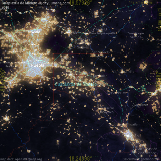
Analysis of Cuapiaxtla de Madero night lights 2016
Square area 10x10 km:
 0%
0%90-99
1.3%80-89
16.45%70-79
11.9%60-69
13.2%50-59
6.93%40-49
25.11%30-39
21.21%20-29
3.9%10-19
0%0-9
0%Square area 50x50 km:
0.3%90-99
0.86%80-89
4.98%70-79
3.66%60-69
4.79%50-59
2.31%40-49
6.21%30-39
6.98%20-29
9.38%10-19
17.31%0-9
43.21%Clear (daylight) street map image can be seen on geolist.org.
Map coordinates:
19° 34' 45.3" North, 98° 31' 37" West
18° 54' 55.6" North, 97° 49' 25.8" West
18° 14' 56.3" North, 97° 7' 14.5" West
Some cities around Cuapiaxtla de Madero sort by population:
• Acatzingo
8.5 km =5.3 mi,  29°
29°
• Los Reyes de Juárez
4.3 km =2.7 mi, 29°
• Huixcolotla
5.5 km =3.4 mi,  83°
83°
• San Hipólito
5.9 km =3.7 mi,  298°
298°
• Actipan de Morelos
5.6 km =3.5 mi, 27°
• Tochtepec
8.5 km =5.3 mi,  179°
179°
• Hueyotlipan
5.2 km =3.2 mi,  238°
238°
• San Martín Caltenco
3.4 km =2.1 mi,  171°
171°
3530032 (p: 7,139)
Sources (retrieved 2019-11-25):
» Earth at Night: Flat Maps 2012, 2016