Tlanalapa night lights from space
Night Light of Tlanalapa (Hidalgo) from space (Mexico) Src. Average luminocity for 10x10km area is 23.3409% and for 50x50km: 20.0745%.
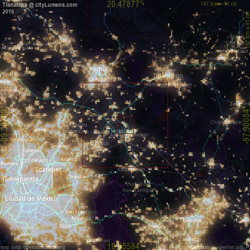
Analysis of Tlanalapa night lights 2016
Square area 10x10 km:
 0.62%
0.62%90-99
1.45%80-89
4.34%70-79
3.51%60-69
2.89%50-59
0%40-49
4.55%30-39
5.17%20-29
7.23%10-19
46.49%0-9
23.76%Square area 50x50 km:
0.58%90-99
0.96%80-89
4.34%70-79
3.14%60-69
2.9%50-59
2.41%40-49
4.17%30-39
3.96%20-29
6.1%10-19
23.04%0-9
48.41%Clear (daylight) street map image can be seen on geolist.org.
Map coordinates:
20° 28' 43.6" North, 99° 18' 25.5" West
19° 49' 7.2" North, 98° 36' 14.3" West
19° 9' 21" North, 97° 54' 3" West
Some cities around Tlanalapa sort by population:
• Ciudad Sahagun
5.7 km =3.5 mi,  147°
147°
• Apan
20 km =12.4 mi,  126°
126°
• Tepeapulco
6.3 km =3.9 mi,  122°
122°
• Otumba
20.7 km =12.9 mi,  230°
230°
• Emiliano Zapata
19.2 km =11.9 mi,  161°
161°
• Zempoala
12.6 km =7.8 mi,  329°
329°
• Tezontepec
23.6 km =14.7 mi,  286°
286°
• Jaltepec
10.4 km =6.5 mi,  197°
197°
3515399 (p: 7,518)
Sources (retrieved 2019-11-25):
» Earth at Night: Flat Maps 2012, 2016