Emiliano Zapata night lights from space
Night Light of Emiliano Zapata (Hidalgo) from space (Mexico) Src. Average luminocity for 10x10km area is 26.9194% and for 50x50km: 15.276%.
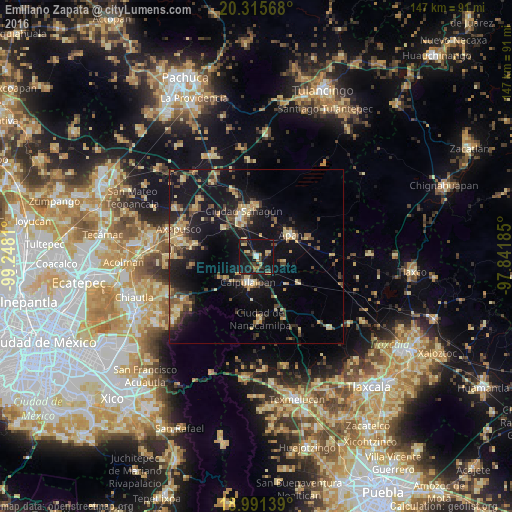
Analysis of Emiliano Zapata night lights 2016
Square area 10x10 km:
 0.83%
0.83%90-99
1.65%80-89
5.58%70-79
3.51%60-69
3.72%50-59
1.45%40-49
6.4%30-39
5.99%20-29
6.2%10-19
55.17%0-9
9.5%Square area 50x50 km:
0.32%90-99
0.72%80-89
3.6%70-79
2.4%60-69
1.92%50-59
1.71%40-49
2.89%30-39
3.13%20-29
4.22%10-19
17.87%0-9
61.22%Clear (daylight) street map image can be seen on geolist.org.
Map coordinates:
20° 18' 56.4" North, 99° 14' 53.2" West
19° 39' 17.6" North, 98° 32' 41.9" West
18° 59' 29" North, 97° 50' 30.7" West
Some cities around Emiliano Zapata sort by population:
• Calpulalpan
7.8 km =4.8 mi,  199°
199°
• Ciudad Sahagun
13.8 km =8.6 mi,  346°
346°
• Apan
11.7 km =7.3 mi,  57°
57°
• Tepeapulco
14.9 km =9.3 mi,  356°
356°
• Ciudad de Nanacamilpa
18 km =11.2 mi,  177°
177°
• Tlanalapa
19.2 km =11.9 mi,  341°
341°
• Benito Juárez
14.4 km =8.9 mi,  122°
122°
• Jaltepec
12.5 km =7.8 mi,  311°
311°
3527876 (p: 8,722)
Sources (retrieved 2019-11-25):
» Earth at Night: Flat Maps 2012, 2016