Tepeapulco night lights from space
Night Light of Tepeapulco (Hidalgo) from space (Mexico) Src. Average luminocity for 10x10km area is 29.6508% and for 50x50km: 15.9816%.
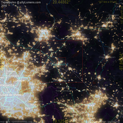
Analysis of Tepeapulco night lights 2016
Square area 10x10 km:
 2.27%
2.27%90-99
2.48%80-89
8.88%70-79
5.37%60-69
3.51%50-59
1.45%40-49
3.1%30-39
6.61%20-29
5.58%10-19
26.65%0-9
34.09%Square area 50x50 km:
0.31%90-99
0.67%80-89
3.53%70-79
2.7%60-69
1.88%50-59
1.54%40-49
3.01%30-39
3.18%20-29
4.7%10-19
21.47%0-9
57.03%Clear (daylight) street map image can be seen on geolist.org.
Map coordinates:
20° 26' 55" North, 99° 15' 20.8" West
19° 47' 18.2" North, 98° 33' 9.6" West
19° 7' 31.5" North, 97° 50' 58.3" West
Some cities around Tepeapulco sort by population:
• Calpulalpan
22.3 km =13.9 mi,  184°
184°
• Ciudad Sahagun
2.7 km =1.7 mi,  238°
238°
• Apan
13.7 km =8.5 mi,  128°
128°
• Otumba
23.5 km =14.6 mi,  245°
245°
• Emiliano Zapata
14.9 km =9.3 mi, 176°
• Tlanalapa
6.3 km =3.9 mi,  302°
302°
• Zempoala
18.5 km =11.5 mi,  320°
320°
• Jaltepec
10.8 km =6.7 mi,  232°
232°
3515902 (p: 15,244)
Sources (retrieved 2019-11-25):
» Earth at Night: Flat Maps 2012, 2016